In This Guide
Baltimore sits at the crossroads of the Northeast Corridor, a working waterfront city where maritime heritage, industrial legacy and urban reinvention shape daily life. It's a place where the past is visibly woven into the present—old factory districts share space with research institutions, and the harbor remains central to both commerce and leisure. Roughly 570,000 people live here, making Baltimore a significant regional hub with a character distinctly its own.
First Impressions and Setting
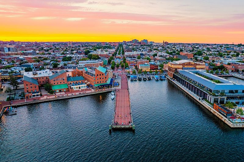
Baltimore occupies low-lying terrain near the Patapsco River estuary, sitting roughly 35 meters above sea level. The city spreads across both sides of the harbor, with the Inner Harbor serving as a focal point for visitors and locals alike. The landscape is fundamentally shaped by water—the Chesapeake Bay lies nearby, and the harbor cuts deep into the urban fabric, creating distinct neighborhoods and a strong sense of place tied to maritime activity.
The harbor district has undergone substantial redevelopment over recent decades. The waterfront now mixes restored historic structures with modern commercial and residential buildings, creating visual contrasts that signal Baltimore's ongoing transformation. Away from the harbor, the city spreads into older residential neighborhoods with distinctive row-house architecture. The elevation is modest enough that the city doesn't feel mountainous, but the waterfront location and proximity to the bay give it a geographic identity tied to the sea.
History, Identity and Local Stories
Baltimore was established in the late 18th century and developed as a major port. The city's significance grew through the 19th and 20th centuries as a manufacturing and shipping center. The harbor economy—built on trade, fishing, shipbuilding and cargo handling—anchored the city's prosperity for generations.
The industrial period left deep marks on Baltimore's structure and identity. Manufacturing plants, warehouses, canneries and related facilities concentrated along the harbor and spreading into neighborhoods to the east and south. This industrial past shaped everything from neighborhood layout to workforce composition to civic pride. The Baltimore Assembly plant, operated by General Motors, exemplifies this heritage—it opened in 1935 to produce Chevrolets and operated as a major employer until its closure in 2005. That facility's presence in the Canton district east of the Inner Harbor reflects the broader pattern of manufacturing corridors that once defined the city's economic geography.
The evidence of this industrial era remains visible throughout Baltimore. Converted warehouses, historic industrial districts, and neighborhoods built to house factory workers are part of the physical landscape. Museums and cultural institutions now document this heritage, allowing visitors to understand how Baltimore's waterfront economy functioned and what role manufacturing played in the city's development.
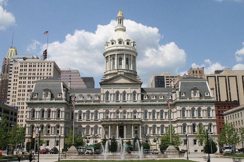
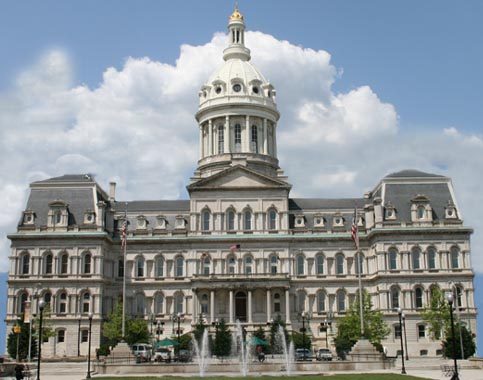
In 1851, Baltimore achieved status as an independent city under the Maryland Constitution, a distinction that persists today. The city is not under county jurisdiction, a formal reality that reflects its historical importance as a major urban center. This independent status, while primarily administrative, underscores Baltimore's role as a distinct entity within Central Maryland.
Daily Life, Economy and Culture
Baltimore remains a working city with a diversified economy. The port continues to handle significant cargo traffic, maintaining the harbor's maritime function. Educational and research institutions contribute substantially to the local economy and character—the University of Maryland, Baltimore County (located nearby in Catonsville) represents the broader educational infrastructure supporting the region, with research programs, undergraduate education and the state's first university research park.
The harbor district and surrounding neighborhoods support significant service and hospitality sectors, alongside healthcare, education and professional services. Neighborhoods vary considerably in character, from waterfront-focused areas to residential communities inland. The city's workforce reflects its post-industrial transition—fewer manufacturing jobs than historically, but continuing port activity, healthcare employment, educational institutions, and growing sectors like technology and creative industries.
Cultural institutions and public spaces anchor daily life. The Baltimore Museum of Industry, located in the Riverside neighborhood south of Federal Hill, documents the city's manufacturing heritage and remains a marker of how Baltimore's residents understand their own history. The Port Covington district in Riverside represents newer development patterns, including offices for The Baltimore Sun newspaper and the Under Armour Waterfront headquarters, showing how former industrial areas are being repurposed for contemporary uses.
The city's neighborhoods each have distinct characters, though sources specific to local districts are limited. What's clear is that Baltimore's residential landscape reflects generations of settlement patterns tied to port work, manufacturing employment and successive waves of migration and demographic change.
What Visitors Notice
Arriving in Baltimore, the waterfront dominates the visual landscape. The Inner Harbor draws visitors and serves as a natural gathering point, with a mix of historic and contemporary buildings creating varied streetscapes. The water itself—whether the harbor basin, the broader Patapsco estuary or views toward the Chesapeake Bay—is never far away, and this maritime setting is fundamental to how the city feels.
Historic neighborhoods retain older architecture and street patterns that reflect 19th and early 20th-century urban development. The row-house aesthetic is characteristic of Baltimore's residential districts. Industrial-era buildings—warehouses, factories, processing plants—are visible throughout, particularly in waterfront areas and neighborhoods to the east and south of downtown. Many of these structures have been adaptively reused, repurposed as apartments, offices, galleries or cultural spaces.
The landscape is generally accessible and navigable on foot in the central and waterfront areas, though the city spreads across considerable territory. The terrain is relatively flat, with few dramatic elevation changes. Weather follows the Atlantic seaboard pattern, with hot summers and cold winters typical of the Mid-Atlantic region.
Getting There and Around
Baltimore is served by regional transportation networks. The Washington–Baltimore corridor places it within the broader Northeast transportation system, connecting it to other major cities. Local and regional transit options exist, though specific current services should be verified before travel. The port remains functional and handles passenger and cargo vessels, reflecting Baltimore's continued maritime role.
Practical Notes
The city operates on Eastern Time (America/New_York). Current travel conditions and services change seasonally and year to year, so visitors should check local resources for current transit, accommodation and activity information. Baltimore is part of the larger Baltimore metropolitan area and the Washington–Baltimore combined statistical area, placing it within a much larger regional context of roughly 10 million people. Its independent city status and harbor-centered geography give it a distinct character within this larger region.
Baltimore Museum of Art
The Baltimore Museum of Art (BMA) sits on North Charles Street near 31st Street, in the Charles Village neighbourhood north of downtown. It holds one of the most significant art collections on the East Coast, offered to visitors at no general admission charge — a policy that sets it apart from many institutions of comparable scale.
The Cone Collection
The BMA's most internationally recognised holding is the Cone Collection, assembled in the early 20th century by Baltimore sisters Claribel and Etta Cone. The sisters made repeated visits to Paris, where they developed close relationships with Henri Matisse and Pablo Picasso and built a collection of approximately 3,000 objects. The Cone Collection includes more than 600 works by Matisse alone — paintings, sculptures, drawings, prints and illustrated books — making it one of the largest and most important concentrations of Matisse's work anywhere in the world. Among the collection's best-known pieces are Matisse's Blue Nude (1907) and Large Reclining Nude (1935), as well as Paul Cézanne's Mont Sainte-Victoire Seen from the Bibémus Quarry. Before coming to the museum, much of this collection was displayed in the Cone sisters' own Baltimore apartments. Matisse visited Baltimore in 1930, reportedly the first time he saw the full scope of what the sisters had gathered. The BMA now houses a dedicated Ruth R. Marder Center for Matisse Studies in connection with the collection.
Broader Collection and Exhibitions
Beyond the Cone Collection, the BMA holds 19th-century, modern and contemporary works spanning an internationally diverse range of artists and periods. The museum mounts rotating special exhibitions alongside its permanent galleries. Visitors should check the BMA's official website for current exhibition details, as the programme changes throughout the year. The museum's collection overview and visiting information are available at artbma.org.
Visiting Practicalities
General admission to the BMA's permanent collection is free, though some special exhibitions may require tickets. The museum is located near North Charles and 31st Streets and is accessible by public transport. Visitors entering from the Zamoiski East Entrance should note that access arrangements are subject to change; check current details on the museum's website before visiting. The BMA is one of several major Baltimore cultural institutions — the Walters Art Museum in Mount Vernon is another — that offer free general admission, making both accessible without significant cost.
Sources: Plan Your Visit - Baltimore Museum of Art • Collection Overview - Baltimore Museum of Art • Ruth R. Marder Center for Matisse Studies - Baltimore Museum of Art • The Baltimore Museum of Art - Visit Baltimore • Modern Art - Baltimore Museum of Art
Fells Point and Baltimore's Historic Waterfront Neighbourhoods
Baltimore's waterfront stretches well beyond the Inner Harbor. The neighbourhoods clustered along the harbour's edge — Fells Point to the east, Federal Hill to the south and Canton further east still — each carry distinct histories rooted in the port economy that shaped the city for two centuries. Fells Point is the oldest and most visited of these districts, and the most directly connected to Baltimore's maritime past.
Sources: Fell's Point Neighborhood Guide - Visit Baltimore • Fells Point - Wikipedia • Fells Point - Live Baltimore • USS Constellation - Historic Ships in Baltimore • USS Constellation (1854) - Wikipedia • The Society for the Preservation of Federal Hill and Fells Point
Artscape Festival
Artscape is described by its organisers and city officials as the largest free outdoor arts festival in the United States. Held annually in Baltimore, it draws large crowds for a weekend of visual art, live music, performance and community programming — all at no charge to attendees.
History and Scale
Artscape has been held annually since 1982. Its early editions featured artists including Ray Charles, Ethel Ennis and musicians from the Baltimore Symphony Orchestra. Over subsequent decades it grew into a large-scale event drawing well over 100,000 attendees, with headlining musicians across multiple stages, visual arts exhibitions, interactive exhibits, poetry workshops, street dance and art cars. At its peak in its original location, the festival was reported to attract upwards of 350,000 people.
Station North and the Festival's Geography
For most of its history — from the 1980s through to recent years — Artscape was held in the Mount Royal cultural district, primarily along North Charles Street and Mount Royal Avenue, in and around what became the Station North Arts and Entertainment District. Station North, formally designated as Baltimore's first arts and entertainment district, developed as a hub for galleries, studios, creative businesses and arts organisations. The festival expanded up Charles Street to North Avenue in 2008, drawing on the creative energy concentrated in that part of the city.
A Changing Festival Model
In 2025, Artscape relocated from Station North to Baltimore's downtown core, as part of a city-led strategy to use the festival as a tool for urban revitalisation in underutilised downtown spaces. The 2025 edition, held on 24-25 May, drew well over 100,000 attendees according to a press release from Mayor Brandon Scott's office. Artscape's organisers have described the move as a redefinition of the festival model. The Station North community has responded with mixed views, with local arts leaders affirming that the district retains its identity as a cultural hub independent of the festival's location.
What the Festival Offers Visitors
Artscape features interactive visual arts exhibits, musical performances across multiple stages, poetry workshops, street dance, film screenings and family-friendly activities. Art cars — decorated vehicles that have become a visual signature of the event — are part of the outdoor experience. Food vendors are present throughout the festival site. Admission to the festival itself is free. Visitors planning to attend should check the official Artscape website (artscape.org) and Visit Baltimore for current dates, venue and programming details, as the festival's format and location have been in transition.
Sources: Artscape - Official Website • Artscape - Wikipedia • Artscape - Visit Baltimore • Mayor Scott Highlights Success of Artscape 2025 - Baltimore City • Station North Community Reacts to Artscape's New Downtown Footprint - Baltimore Magazine