
In This Guide
Christchurch is the largest city on New Zealand's South Island and the country's second-largest urban area by population. It sits on the flat eastern edge of the Canterbury Plains, bounded by the Pacific Ocean to the east and the ancient volcanic mass of Banks Peninsula to the south. The Port Hills separate the city from Lyttelton Harbour, and on clear days the Southern Alps are visible to the west. The Avon River — known in te reo Māori as Ōtākaro — runs through the centre, and a long green corridor along its banks gives the city a walkable, unhurried quality that surprises visitors expecting something grittier from a regional centre of this size.
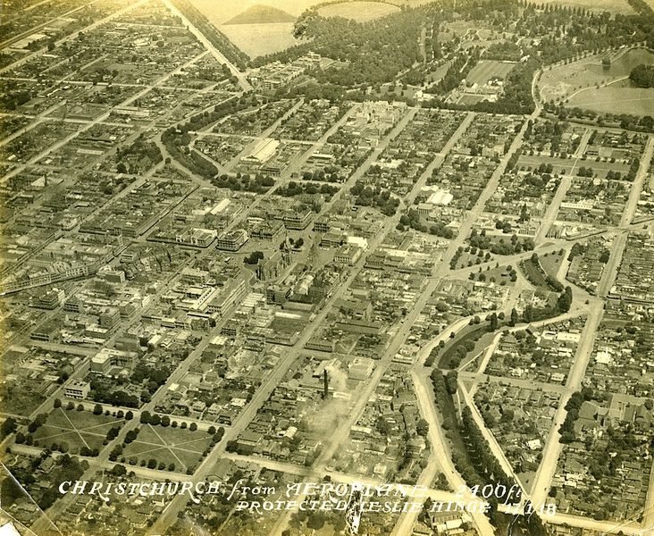
What defines Christchurch most clearly today is the fact of its rebuilding. A series of earthquakes beginning in September 2010, and most destructively in February 2011, killed 185 people and demolished much of the central city. The rebuilt centre is noticeably different from what existed before: more open in places, architecturally varied, with new structures sitting alongside surviving heritage buildings and public spaces created in the aftermath of demolition. Visitors should understand that this recent history is not background — it is the city as it now exists.
Setting and Orientation
The city is notably flat, which makes it manageable on foot or by bicycle for visitors staying centrally. Christchurch Airport functions as the main international and domestic gateway for the South Island, and the city's public bus network serves urban routes. The Ōtākaro / Avon River Precinct runs through the central city, with paths, open lawn, and willows along the water. Hagley Park, a large public park adjoining the precinct, contains the Christchurch Botanic Gardens, which are free to enter and accessible from the central city.
Banks Peninsula is not within the city boundary but is closely linked to Christchurch's wider identity. The peninsula's main towns, Akaroa and Lyttelton, are accessible by road and offer volcanic headlands, sheltered bays, and coastal character distinct from the flat city. A hire car is the most practical option for exploring the peninsula and the wider Canterbury region, as public transport connections to those areas are limited. Visitors should check current timetables and routes locally before travelling.
History and Identity
Christchurch carries the nickname "Garden City," a reflection of its greenery and of the English ideals that shaped its original layout. Its street plan, parks, and the original Christ Church Cathedral in Cathedral Square reflected a deliberate colonial design to transplant aspects of southern England to the Southern Hemisphere. The Ōtākaro River was a gathering and travel route for Māori long before European settlement, and that heritage is expressed in the dual naming of the city's central waterway and in its Māori name, Ōtautahi.
The University of Canterbury, founded in 1873 as Canterbury College, is New Zealand's second-oldest university. Canterbury itself is one of New Zealand's most productive agricultural regions, and Christchurch functions as its commercial and service centre. The metropolitan population, including surrounding districts, is approximately 556,500, making this a genuine regional hub rather than a large town.
The Earthquakes and the Rebuilt City
The February 2011 earthquake — magnitude 6.2, shallow and close to the city centre — caused the greatest destruction. The 185 deaths included people in the collapsed CTV and PGC buildings. Large areas of the central city were subsequently demolished, and the decade that followed became one of the most extensive urban reconstruction projects in the Southern Hemisphere.
The rebuilt city centre is the result of that effort. New architecture coexists with surviving heritage buildings, and some sites remain as deliberate reminders of what was lost. Christ Church Cathedral in Cathedral Square was severely damaged and has been the subject of a long-running reinstatement project; a temporary structure known as the Transitional Cathedral — commonly called the Cardboard Cathedral — was erected on Latimer Square as a functioning replacement and has become one of the more recognised buildings in the rebuilt city. The scale of change means that any pre-2011 description of central Christchurch is an unreliable guide to what visitors will find today.
What to See and Do
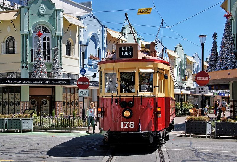
The Christchurch Botanic Gardens, within Hagley Park, are free to enter and accessible year-round. A paid guided tour of the gardens is available, as is a separate tram day pass that allows visitors to board and alight at stops around the central city, including Cathedral Square, Victoria Square, New Regent Street, the Art Gallery, and the museum. Punting on the Avon is a well-established visitor activity: flat-bottomed boats depart from the Antigua Boat Sheds for routes through the Botanic Gardens (year-round) or from Worcester Bridge through the central city Avon River Precinct (summer only). Bookings are required for punting.
The Christchurch Gondola provides access to elevated views from the Port Hills, overlooking the city, the plains, and the sea. The Canterbury Museum, on Rolleston Avenue near the Botanic Gardens entrance, covers natural and human history of the region; visitors should check current opening arrangements as museum operations can change. The Arts Centre, a Victorian Gothic complex near the Botanic Gardens, houses galleries, studios, and food and drink venues.
The Port Hills provide walking tracks with views over the city toward the sea and the Canterbury Plains. Banks Peninsula — reached via road through Lyttelton or to Akaroa — offers volcanic coastal scenery and is suited to a half-day or full-day excursion from the city.
Practical Information
Both UK and US governments classify New Zealand at their lowest advisory level, meaning normal travel precautions apply. There are no current security restrictions affecting Christchurch or the Canterbury region. New Zealand sits on active seismic fault lines, and visitors should familiarise themselves with basic earthquake preparedness guidance — standard advice throughout the country. The New Zealand government and local civil defence resources provide this guidance.
Christchurch uses New Zealand Standard Time. Currency is the New Zealand dollar (NZD). The city has a temperate oceanic climate with regular moderate rainfall; visitors should pack for all weather conditions regardless of season. The flatness of the central city makes it navigable by bicycle. For travel beyond the urban area — to Banks Peninsula, the Port Hills, or the wider Canterbury region — a hire car is the most practical option.
Christchurch Botanic Gardens and Hagley Park
The Christchurch Botanic Gardens and the surrounding Hagley Park form the largest and most visited public green space in the city. Located within the Ōtākaro / Avon River bend, a short walk from Cathedral Square, the gardens cover 21 hectares and are free to enter every day from 7am. They sit within the much larger Hagley Park — a public reserve of around 165 hectares — giving the area a scale unusual for a central urban location.
Sources: Christchurch Botanic Gardens - Wikipedia • Christchurch Botanic Gardens - Christchurch City Council • Christchurch Botanic Garden - New Zealand Garden Trust • Hagley Park and Gardens - Christchurch City Council
Banks Peninsula and Akaroa Day Trip
Banks Peninsula is an ancient volcanic complex that rises from the Canterbury Plains roughly 80 kilometres south-east of Christchurch city centre. Its dramatic headlands, deeply incised harbours and sheltered bays make it one of the most distinctive landscapes accessible as a day trip from a major New Zealand city. The peninsula's main town, Akaroa, sits at the head of Akaroa Harbour — the largest body of water on the peninsula — and is around 90 minutes by road from central Christchurch. It is also accessible via a daily scheduled bus service, the Akaroa French Connection, which departs from central Christchurch with commentary and photo stops along the route.
Sources: Akaroa and Banks Peninsula - ChristchurchNZ.com • Hector's Dolphins - Black Cat Cruises • Akaroa Kayaks - Hector's Dolphin Sanctuary
Cardboard Cathedral (Transitional Cathedral)
The Transitional Cathedral — known almost universally as the Cardboard Cathedral — is one of the most architecturally distinctive buildings to have appeared in Christchurch since the 2011 earthquake. Opened in August 2013, it was designed by the Japanese architect Shigeru Ban, working in association with the New Zealand firm Warren and Mahoney. The building takes its popular name from its most unusual structural element: more than 90 large cardboard tubes form the walls and roof. It was constructed as a temporary place of worship and community space while the original Christ Church Cathedral in Cathedral Square undergoes long-term reinstatement work following earthquake damage. In practice, the building has become a landmark in its own right.
Sources: Cardboard Cathedral official site • Cardboard Cathedral - Wikipedia • Christ Church Cathedral, Christchurch - Wikipedia • Christchurch Transitional Cardboard Cathedral - ChristchurchNZ.com • Christ Church Cathedral Reinstatement Project