What Boston is known for
Boston occupies the Shawmut Peninsula on Massachusetts' Atlantic coast, serving as New England's cultural and financial centre. The city of 653,833 residents anchors a metropolitan area of 4.9 million. Its harbour remains a defining feature—visible from many points in the city, still functioning as a working port. The compact geography, substantially altered from its original topography through centuries of landfill, creates distinct neighbourhoods where colonial-era brick buildings stand alongside modern research facilities and glass towers. The city functions as both historical landmark and active economic hub, with education, healthcare, finance, and technology driving its contemporary identity.
Arriving in Boston
Boston sits at the intersection of major transport corridors serving New England. Logan International Airport provides the primary air access point. The Massachusetts Bay Transportation Authority (MBTA), known locally as the T, operates subway, bus, and commuter rail services throughout the metropolitan area. The city's compact core and established public transport network make car ownership unnecessary for visitors staying in central areas. Amtrak serves South Station and Back Bay Station, connecting Boston to New York, Washington, and destinations along the Northeast Corridor.
The harbour geography influences how the city is laid out. Boston Common, the oldest public park in the United States, serves as a traditional reference point for orientation. The Public Garden sits adjacent. From these central green spaces, major neighbourhoods radiate outward: Beacon Hill with its brick townhouses and narrow streets, the North End along the waterfront, Back Bay with its Victorian brownstone architecture extending toward Fenway, and the Theatre District near the Common.
Revolutionary History and Urban Development
The Puritan settlement established in 1630 on what was then the Shawmut Peninsula developed into one of colonial America's principal ports. Indigenous peoples had inhabited the area before European arrival; English clergyman William Blaxton maintained a solitary presence between 1624 and 1630 before the main Puritan migration.
Boston's role in the American Revolution remains central to its identity. The Siege of Boston (1775-1776) marked the opening phase of the Revolutionary War. Events leading to the conflict—including the Boston Massacre, the Boston Tea Party, and early resistance to British taxation—occurred throughout the city. The physical locations where these events took place remain preserved and integrated into the urban fabric.
The 19th century brought industrial prosperity through wool processing, textile manufacturing, and the production of clothing, leather goods, and shoes. A merchant class developed significant wealth and established many of the city's cultural institutions. The Great Fire of 1872 destroyed much of the downtown commercial district, requiring extensive rebuilding. The abolitionist movement found strong institutional support in Boston during the decades before the Civil War.
The 20th century brought both decline and renewal. The Big Dig project, completed in the 2000s, removed an elevated highway that had separated the city from its waterfront since the 1950s. This infrastructure transformation reconnected neighbourhoods to the harbour and altered downtown traffic patterns fundamentally. The project took over a decade and substantially exceeded initial budget projections, but delivered the urban transformation promised.
The Freedom Trail
The Freedom Trail provides a 2.5-mile red-brick walking route connecting 16 Revolutionary War-era sites. Starting from Boston Common, the trail runs through downtown and the North End to Charlestown, passing locations including the Old State House, where the Declaration of Independence was first read to Boston residents, Faneuil Hall, which served as a meeting place for revolutionary discussions, the Paul Revere House dating to around 1680, and the Old North Church, associated with the signal lanterns of 1775. The trail is marked clearly on pavements and functions as both historical interpretation and practical walking route through central neighbourhoods. Guided tours operate regularly; the trail can also be walked independently using the published map and site descriptions.
Where to Stay in Boston
Back Bay offers Victorian brownstone architecture, proximity to the Public Garden and Newbury Street shopping, and access to the Green Line. The neighbourhood provides restaurants, accommodation at various price points, and a residential character while remaining 10-15 minutes on foot from major tourist sites.
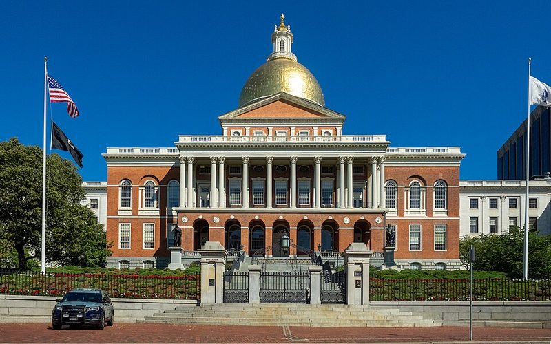
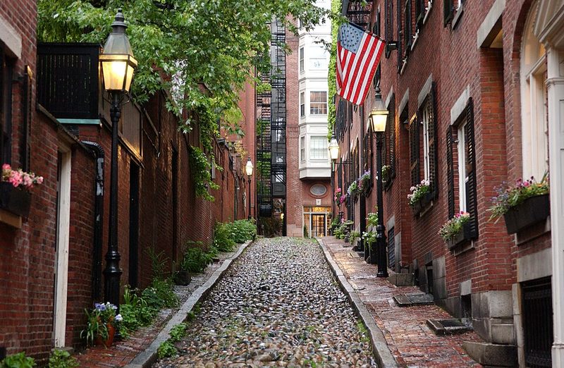
Beacon Hill presents narrow brick-paved streets, gas lamps, and Federal-style townhouses. The neighbourhood sits adjacent to Boston Common and the Massachusetts State House. Accommodation here tends toward higher price points but offers immediate access to downtown and the Theatre District.
The North End, Boston's oldest residential neighbourhood, contains Italian restaurants, historic sites on the Freedom Trail, and waterfront access. The area offers a more neighbourhood-focused experience with bakeries and local businesses alongside tourist infrastructure.
The Seaport District represents recent development with modern hotels, restaurants, and the Institute of Contemporary Art. The neighbourhood lacks the historic character of Back Bay or Beacon Hill but provides newer facilities and waterfront location. Transit connections to downtown are less established than in older neighbourhoods.
Museums and Cultural Institutions
The Museum of Fine Arts, one of the largest art museums in the United States, contains over 100 galleries spanning cultures and periods. The collection includes Egyptian antiquities, Asian art, European paintings, and American works. The museum requires several hours for even a selective visit.
The Isabella Stewart Gardner Museum opened in 1903 in a building designed to house Gardner's personal collection. The museum preserves her arrangement of artworks, displaying paintings, sculpture, and decorative objects from different periods in an intentional domestic context rather than conventional museum organisation. The museum gained notoriety following a 1990 theft that removed 13 works; the empty frames remain on display. A contemporary wing designed by Renzo Piano opened in 2012.
The Institute of Contemporary Art in the Seaport District occupies a cantilevered building overlooking the harbour. The museum focuses on contemporary art exhibitions and maintains a permanent collection of post-1960s works. The building itself, completed in 2006, provides harbour views and has received architectural recognition.
Economy and Contemporary Boston
Education and healthcare anchor Boston's economy. Harvard University and the Massachusetts Institute of Technology, though located in Cambridge across the Charles River, form part of the greater Boston academic ecosystem that includes Boston University, Northeastern University, and numerous smaller institutions. This concentration of universities generates research activity, startup companies, and a steady population of students and academics.
The medical and healthcare sector provides substantial employment. Major teaching hospitals affiliated with Harvard Medical School and other institutions have established Boston as a centre for medical research and treatment.
Finance and technology represent significant employment sectors. The financial services industry, established in the 19th century, continues with major firms headquartered or maintaining substantial presence in the city. High-technology companies, particularly in biotechnology and software, have developed along the Route 128 corridor and increasingly in Boston proper.
The city experienced economic difficulty between 1988 and 1992, followed by recovery through the 1990s. The September 11, 2001 attacks had notable impact—the region lost nearly 32,000 jobs between 2001 and 2004. Recovery began in 2004, with tourism and employment rebounding. The education and healthcare sectors demonstrated more resilience during this period than technology or finance.
Day Trips and Regional Access
Salem lies 25 km north of Boston, accessible by commuter rail. The city is known for the 1692 witch trials and maintains several museums and historic sites related to that period, as well as maritime heritage sites reflecting its history as a major port.
Concord and Lexington, immediately west of Boston, contain sites related to the opening battles of the Revolutionary War on 19 April 1775. Concord also has associations with 19th-century American writers including Ralph Waldo Emerson, Henry David Thoreau, Louisa May Alcott, and Nathaniel Hawthorne, whose homes and the Sleepy Hollow Cemetery can be visited.
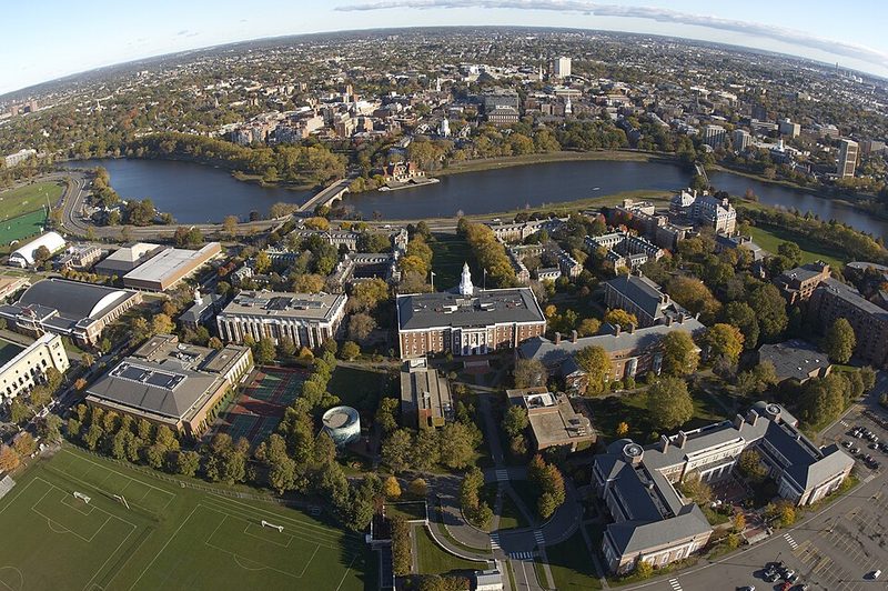
Cambridge, immediately across the Charles River, contains Harvard University (founded 1636) and MIT. Harvard Square functions as a district with bookshops, restaurants, and street activity. The Harvard Art Museums and natural history collections are open to visitors. The MIT campus includes the MIT Museum and notable modernist architecture.
Cape Cod extends into the Atlantic approximately 100 km south of Boston. The peninsula attracts summer visitors for beaches, coastal towns, and seafood restaurants. Provincetown at the Cape's tip has particular identity as an arts community and LGBTQ+ destination. The Cape is accessible by car or seasonal ferry service.
Practical Considerations
Boston experiences four distinct seasons. Winters bring cold temperatures and regular snowfall; January averages around -1°C. Summers are warm and humid; July averages around 24°C. Spring and autumn offer moderate temperatures, with autumn particularly noted for foliage in surrounding New England regions. The city functions year-round, but outdoor walking and harbour activities are most comfortable from late spring through early autumn.
The MBTA subway system (the oldest in the United States) provides access to major neighbourhoods and attractions. The system consists of colour-coded lines—Red, Orange, Blue, and Green—that converge downtown. The Green Line operates street-level sections as a light rail system. Bus routes supplement rail service. The system shows its age with maintenance needs, but covers the essential tourist geography reliably. The CharlieCard provides fare payment across all MBTA services.
Boston hosts seven FIFA World Cup 2026 matches in June and July at Gillette Stadium in Foxborough, approximately 40 km southwest of the city. This will bring increased visitor numbers and accommodation pressure during that period. Those planning visits in summer 2026 should book accommodation well in advance and expect higher prices around match dates.
Is Boston Worth Visiting?
Boston merits attention primarily for those interested in American Revolutionary history, where the density of preserved sites and the Freedom Trail provide accessible interpretation not available elsewhere. The concentration of cultural institutions—particularly art museums and the university environments of Cambridge—adds appeal beyond the historical focus. The city's compact geography allows efficient exploration on foot and by public transport. Those seeking primarily natural landscapes or beach destinations will find better options elsewhere in New England, but for urban historical and cultural content, Boston delivers substance.