What El Paso is known for
El Paso sits at one of North America's most consequential crossroads—where Texas, New Mexico, and Mexico converge along the Rio Grande. With nearly 680,000 residents, it ranks as the sixth-most populous city in Texas and 22nd in the United States, yet remains unfamiliar to many visitors. The city functions primarily as a working border metropolis rather than a tourism showcase, its character shaped by trade, military presence, and a genuinely binational relationship with Ciudad Juárez directly across the river.
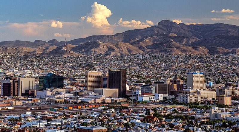
The landscape is stark. El Paso occupies a high desert basin at the foot of the Franklin Mountains, which rise sharply from the urban grid and extend northward for 23 miles. The elevation climbs from around 3,500 feet at the Rio Grande to over 7,000 feet in the peaks. Summer temperatures regularly exceed 100 degrees Fahrenheit, though the air is dry and rainfall sparse—only about 7.77 inches annually. The light is intense year-round, and the mountains dominate sightlines from most parts of the city.
Arrival and First Impressions
The clarity of the air and the scale of the mountains are immediate. North Franklin Mountain reaches 7,192 feet and is visible from downtown. The sense of elevation and openness—wide skies, long sight lines—shapes how the city feels. The desert context is austere: creosote scrub, arroyos, and bare rock predominate.
The Rio Grande flows through a deeply carved valley, and the international boundary runs along its course. Looking south from El Paso proper, Ciudad Juárez sits directly across the water. This is not one city but a genuinely binational metropolitan region. The bilingual character is visible in signage, street life, and commerce. Spanish names predominate in many neighbourhoods, and the proximity to the border means that movement across the boundary, though subject to US immigration procedures, is part of ordinary El Paso experience for many residents.
The Rio Grande itself, despite its reputation, appears modest to many visitors. In the desert context it is indeed a lifeline, but it is a working river here, channelled and managed, not a scenic feature.
History and Settlement
Spanish explorers, possibly including Ãlvar Núñez Cabeza de Vaca, first reached this mountain pass in the sixteenth century. They named it El Paso del Norte—the Pass of the North—for the dramatic narrows through which north-south travel had to pass. Franciscan friars established a settlement at the pass itself, making it a strategic waypoint on colonial routes long before El Paso, Texas, existed as a formal city.
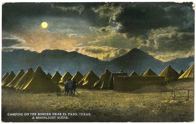
For three centuries, the region served as a continental crossroads under Spanish and Mexican authority. Most settlement lay south of the present border, in what is now Ciudad Juárez. The configuration changed in 1848, when the Rio Grande became an international boundary following the Mexican-American War. Traffic patterns shifted from north-south to east-west, and the settlement that would become El Paso began to grow on the north bank. Fort Bliss was established as a cavalry post that same year, anchoring military presence. The city itself was officially established in 1850.
Before Spanish contact, the region was home to Apache peoples, who were nomadic hunters and gatherers, and Pueblo communities, who settled and farmed. Pueblo traditions of pottery and weaving persisted through centuries of colonial rule and remain part of the cultural inheritance of the area today. The Tigua (Ysleta del Sur Pueblo) maintain a presence in the El Paso area and operate a cultural centre along the Mission Trail.
The Mission Trail
The El Paso Mission Trail is a nine-mile stretch across the Mission Valley that preserves three of the oldest religious structures in Texas. Ysleta Mission, constructed in 1682, is the oldest continuously operating parish in Texas. Socorro Mission and the San Elizario Chapel complete the trail. All three remain active churches serving their communities after more than 300 years.
The trail was designated part of the El Camino Real National Historic Trail in 2000. The missions are white adobe-walled structures, and the surrounding landscape—including the plaza at San Elizario and the historic district there—retains elements of Spanish colonial town planning. The Tigua Indian Cultural Centre and Los Portales Museum and Information Centre provide context for the regional history along the route. Cultural festivals take place along the Mission Trail throughout the year.
Franklin Mountains State Park
Franklin Mountains State Park covers nearly 24,250 acres entirely within city limits, making it one of the largest urban parks in the United States. The park lies just 15 minutes from central El Paso and offers hiking, mountain biking, and rock climbing in high-desert terrain.
Several trails are well-used by locals. The Ron Coleman Trail, which begins at the end of McKelligon Canyon, is a strenuous eight-mile route that ascends to the highest peak in El Paso. The Aztec Cave Trail is shorter—less than three-quarters of a mile—but climbs more than 400 feet past lechuguilla, ocotillo, yucca, and prickly pear cactus. The El Paso Tin Mines Trail is frequently mentioned as a popular route. The Tom Mays unit of the park provides access to backcountry areas. Visitors should verify current trail conditions and access details locally, as summer heat makes timing and preparation critical.
Museums and Cultural Venues
The El Paso Museum of History covers more than 1,000 years of regional history and is located in the heart of the city. Permanent exhibitions include "Mountain of Gold," which challenges conventional narratives of the region and highlights family stories, neighbourhoods, businesses, and community institutions, as well as cultural exchanges along the border.
The El Paso Museum of Art offers free admission to the public and hosts classes. The Centennial Museum and Chihuahuan Desert Gardens, located at the University of Texas at El Paso, is the city's oldest museum and provides an outdoor experience showcasing flora of the Chihuahuan Desert. An annual Florafest allows visitors to purchase plants. The Abraham Chavez Theatre, with three-storey-high windows and a distinctive sombrero-inspired shape, is a recognisable feature in the El Paso skyline and hosts performing arts events.
The Chamizal National Memorial, located along the international border, commemorates the peaceful 1963 resolution of a century-long boundary dispute between the United States and Mexico. The memorial includes a museum, outdoor performance space, and park grounds.
Economy and Daily Life
El Paso's economy rests on multiple pillars. More than 70 Fortune 500 companies maintain operations or headquarters here, including manufacturing firms producing food, clothing, construction materials, electronic equipment, medical devices, and plastics. The area has historical roots in copper refining, though that industry has contracted. Cotton, fruit, vegetables, pecans, and livestock farming continue in the surrounding agricultural areas.
Education is a major employer. Three large school districts together employ more than 19,000 people. The University of Texas at El Paso, founded in 1913 as the State School of Mines and Metallurgy, serves as a significant research and educational institution. UTEP is the third-oldest component of the University of Texas System.
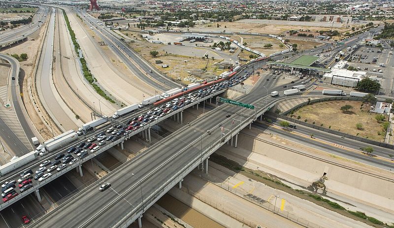
Trade with Ciudad Juárez has always been central to El Paso's character. The cross-border relationship is economic, cultural, and social. El Paso functions as an important entry point for US-bound traffic and goods from Mexico, and that role shapes local commerce, language (Spanish is widely spoken), and daily interaction.
Food and Local Specialities
El Paso's food culture reflects its border position. Mexican cuisine is the foundation, but the city's restaurants span a range from traditional to modern interpretations. Tacos, combo plates, bold salsas, grilled meats, and family-style platters are standard offerings at Tex-Mex establishments throughout the city. L&J Cafe is a long-established local institution. Casa Pantera represents a more modern approach, requiring reservations and offering refined Mexican cuisine.
Locally, visitors will find references to specific neighbourhood favourites, and the food scene is shaped by proximity to Juárez. Several restaurants mentioned by locals include establishments serving food similar to what is available across the border, for those who prefer not to make the crossing.
Practical Considerations
El Paso is accessible by air via El Paso International Airport, by highway, and on foot across international bridges for those entering from Ciudad Juárez. The city operates on Mountain Time, which is worth noting for visitors accustomed to Central Time.
Public transport exists but the city is designed for car use. Verify current public transport routes and schedules locally if needed. The Scenic Drive and Transmountain Road are mentioned by locals as worthwhile routes for viewing the landscape.
Water is scarce, and summer heat is intense. Visitors planning outdoor activities should prepare accordingly. The city's role as a border hub means immigration procedures are present and serious. If you are planning to cross into Mexico, verify current entry and crossing requirements in advance.
Is El Paso Worth Visiting?
El Paso is a real working city, not a curated tourist destination. It offers genuine cross-border character, stark desert landscape, and a long history stretching back to Spanish colonial times. The Mission Trail, Franklin Mountains State Park, and museums provide concrete visitor attractions, and the proximity to Ciudad Juárez adds a binational dimension few other US cities can match. Visitors should manage expectations: this is not a conventional tourism showcase, but it is a place with substance.
Where to Stay in El Paso
Most visitors will find accommodation options concentrated near the airport and along the main commercial corridors. Downtown El Paso provides proximity to museums, the Chamizal Memorial, and the international bridges for those planning to cross into Juárez. The western areas near UTEP offer access to the Franklin Mountains. Specific hotel recommendations should be verified through current booking platforms, as the city's accommodation landscape serves primarily business travellers and those visiting Fort Bliss.
How Many Days Do You Need in El Paso?
Two to three days allows time to cover the Mission Trail, visit Franklin Mountains State Park, and see the main museums. If you plan to cross into Ciudad Juárez or take day trips to nearby areas such as White Sands or Carlsbad Caverns, additional time is warranted. For a focused visit concentrating on El Paso proper, two full days is sufficient for most visitors.
Is El Paso Safe for Visitors?
The UK Foreign, Commonwealth & Development Office advises normal precautions for travel to the United States, with no specific warnings for El Paso. The US State Department issues no travel advisory restricting travel within the United States. El Paso itself has relatively low crime rates for a city of its size. The proximity to the border and Ciudad Juárez means visitors should remain aware of current conditions if planning to cross into Mexico. Check official travel advice for Mexico separately if you intend to visit Juárez. Within El Paso, standard urban precautions apply.
Tigua Indian Cultural Center and Ysleta del Sur Pueblo
The Ysleta del Sur Pueblo, located 15 miles southeast of downtown El Paso, is the oldest community in Texas and home to the Tigua people, who arrived as refugees from the 1680 Pueblo Revolt in New Mexico. The tribe established the Ysleta Mission in 1682, making it the oldest continuously active parish in the state. The Tigua Indian Cultural Center houses a museum documenting over 300 years of tribal history through artefacts, pottery, photographs and video exhibits.
The Pueblo gained federal recognition in 1968 and operates several tribal enterprises, including the cultural center and Speaking Rock Entertainment Center. The adjacent Ysleta Mission, built using traditional adobe techniques, remains an active Catholic church serving the community. Visitors can explore the museum, view the historic Alderette-Candelaria House, and purchase traditional Tigua crafts. The mission operates Monday through Saturday, 7am to 4pm, closed Sundays and holidays.
This is a working tribal community and sovereign nation with 4,696 enrolled members as of 2020. The cultural center attracts national and international visitors and serves as the northern anchor of the El Paso Mission Trail.
Read the full Tigua Indian Cultural Center and Ysleta del Sur Pueblo guide
Sources: Ysleta del Sur Pueblo | Tigua Indians | Cultural Center • Ysleta del Sur Pueblo - Wikipedia • Explore the Ysleta del Sur Pueblo Museum: A Journey into Tigua History • Historic Missions - Diocese of El Paso
Franklin Mountains State Park
Franklin Mountains State Park covers nearly 24,250 acres entirely within El Paso city limits, making it one of the largest urban parks in the United States. The Franklin range runs 23 miles north-south, with North Franklin Peak reaching 7,192 feet. The park sits in the Chihuahuan Desert and offers hiking, mountain biking, rock climbing and camping.
The Tom Mays Unit headquarters provides primary access at 2900 Tom Mays Access Road. Gates open daily 8am to 5pm, with extended hours on weekends from April through early September. Day use costs $5 per person aged 13 and older. The park frequently reaches capacity, and Texas Parks and Wildlife recommends advance reservations.
Popular trails include the Ron Coleman Trail, an 8-mile strenuous hike gaining 3,200 feet to North Franklin Peak, and the shorter Aztec Cave Trail. The El Paso Tin Mines Trail has earned strong visitor ratings. Water is scarce—visitors must carry adequate supplies. Summer temperatures regularly exceed 100°F. The park offers developed campsites, but no lodges or indoor accommodation.
Sources: Franklin Mountains State Park — Texas Parks & Wildlife Department
Chamizal National Memorial
Chamizal National Memorial, two miles northeast of downtown El Paso, commemorates the 1963 peaceful resolution of a century-long boundary dispute between the United States and Mexico. The dispute arose when the Rio Grande shifted course after an 1864 flood, leaving approximately 600 acres of formerly Mexican territory on the north side of the new channel. Presidents Kennedy and López Mateos negotiated the Chamizal Convention, signed 29 August 1963, which divided the land and relocated the river to a fixed concrete channel.
The memorial, administered by the National Park Service, includes a visitor centre, museum, theatre and art galleries. Park grounds open 7am to 10pm daily, with the cultural center operating 10am to 5pm. The site is closed Thanksgiving, Christmas and New Year's Day. Admission is free. The memorial hosts festivals, concerts and educational programmes throughout the year, celebrating the cultures of the borderlands.
A corresponding park, Parque Público Federal El Chamizal, sits on the Mexican side of the boundary. The memorial is considered a model of peaceful border diplomacy and offers a Junior Ranger programme in English and Spanish.
Read the full Chamizal National Memorial guide
Sources: Chamizal National Memorial (U.S. National Park Service) • Chamizal National Memorial - Wikipedia • Operating Hours - Chamizal National Memorial
El Paso Mission Trail
The El Paso Mission Trail is a nine-mile driving route along Socorro Road (FM 258) connecting three historic churches in the Mission Valley: Ysleta Mission (1682), Socorro Mission (1682) and San Elizario Chapel (late 1800s). These are the oldest churches in Texas, all active parishes serving local communities. The trail was designated part of the El Camino Real de Tierra Adentro National Historic Trail in 2000.
Ysleta Mission, the oldest continuously active parish in Texas, was built by Tigua refugees from the Pueblo Revolt using traditional adobe techniques. It operates Monday to Saturday, 7am to 4pm. Socorro Mission, founded by refugees from Socorro Pueblo, retains much of its early 18th-century adobe structure and operates Monday to Friday, 10am to 4pm. San Elizario Chapel sits on a colonial-era plaza surrounded by the San Elizario Historic District, with the Los Portales Museum providing visitor information.
The trail begins 15 miles southeast of downtown El Paso and requires a car, as public transport is limited. The Mission Trail Association operates a visitor center in San Elizario. These are working churches—visitors should respect services and community events.
Sources: El Paso Mission Trail • Historic Mission Trail - Visit El Paso • Historic Missions - Diocese of El Paso