In This Guide
Manila is the capital of the Philippines and, by population density, one of the most densely settled cities proper on the planet — roughly 44,900 people per square kilometre according to the 2024 census. It sits on the eastern shore of Manila Bay on the island of Luzon, barely elevated above sea level, and the bay defines much of what the city looks and feels like: a wide, westward-facing expanse that has shaped trade, light and daily life here for centuries. The 2024 census recorded 1,902,590 residents in the city proper; the wider Metro Manila metropolitan area is considerably larger and surrounds it on all sides.
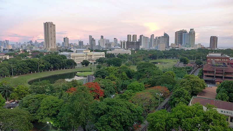
Visitors arriving for the first time tend to find Manila more layered and harder to navigate than a compact heritage city. The old walled district of Intramuros, the national park at Rizal Park (Luneta), and the Binondo district — established in 1594 and recognised as the world's oldest Chinatown — are the most historically grounded entry points. Traffic is a serious daily factor across the whole metropolitan area, and neighbourhood choice matters far more here than in smaller cities.
History and Identity
Few cities in Asia carry as many historical layers as Manila. Spanish colonisers held the Philippine archipelago for 333 years, a presence still visible in Intramuros, in street names and in the city's enduring Catholic identity. The Philippine Revolution against Spanish rule began in 1896, led by the Katipunan movement, and independence was declared in June 1898 — though Spain subsequently sold the islands to the United States under the Treaty of Paris later that year, beginning another phase of foreign rule.
The city's most catastrophic modern chapter came during the Second World War. The Battle of Manila in 1945 brought devastating destruction; the atrocities committed against Filipino civilians during that battle — sometimes referred to as the Rape of Manila — resulted in the deaths of at least 100,000 civilians. It ranks among the worst urban massacres of the twentieth century and remains central to how Manila understands itself. The postwar rebuilding shaped much of the urban fabric that exists today.
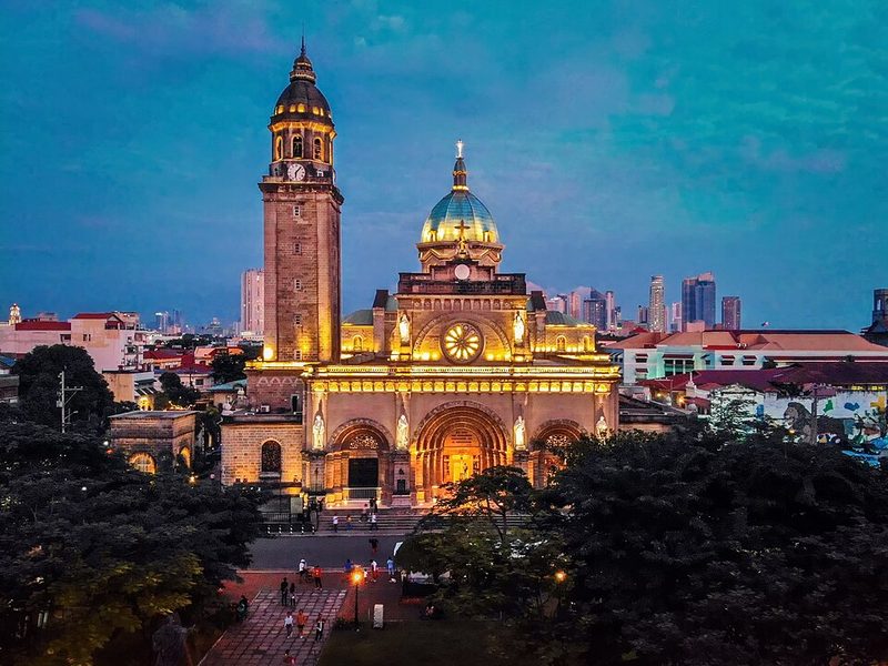
The national hero José Rizal (1861–1896), whose novels Noli Me Tangere and El Filibusterismo challenged Spanish colonial rule, was executed in Manila on 30 December 1896. The site of his execution is now part of Rizal Park, and the National Museum complex in the city holds exhibitions dedicated to his life and work, including his paintings and writings.
Key Areas and Landmarks
Intramuros
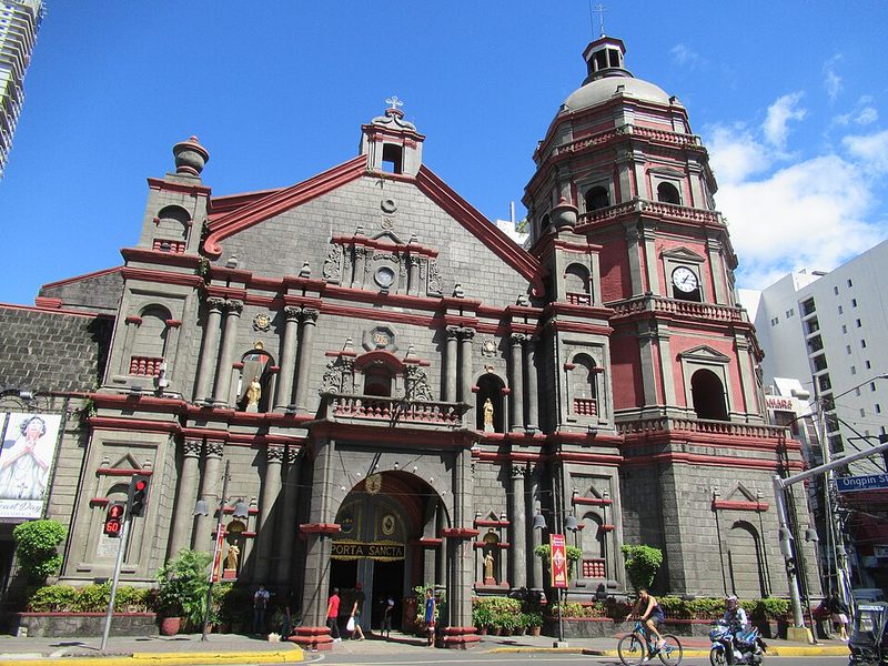
Intramuros — the old walled city — is the most direct physical connection to Manila's colonial past available anywhere in Southeast Asia. The sixteenth-century stone walls enclose churches, plazas and museums including Casa Manila and the Rizal Shrine, housed in the building where Rizal spent his final night before execution. San Agustín Church, a UNESCO World Heritage Site, also stands within the walls. Bamboo bike tours and walking tours of the district are well-established visitor options. The walls themselves can be walked, with remnants of old cannons at intervals; early mornings are quieter than midday when school groups arrive.
Rizal Park (Luneta)
Rizal Park sits immediately outside Intramuros and functions as Manila's main public green space and civic gathering point. The park marks the site of Rizal's execution and contains his monument. Major national events and public gatherings are held here. The bay promenade along Roxas Boulevard, accessible from the park, draws residents in the early mornings and at dusk.
Binondo
Binondo, established by Spanish colonial authorities in 1594 as a settlement for Catholic Chinese migrants across the Pasig River from Intramuros, is recognised as the world's oldest Chinatown. With a current population of around 20,000, it functions today as both a historic district and a concentrated food and commerce corridor. Ongpin Street is the main artery for visitors; the area is known particularly for Chinoy (Chinese-Filipino) cuisine and street food. To Ho Panciteria Antigua on Tomas Pinpin Street, established in 1888 according to historical records, is regarded as the oldest operating panciteria in the Philippines.
The National Museum Complex
The National Museum of the Philippines operates several buildings in the Manila civic district, covering fine arts, natural history and anthropology. The Fine Arts building holds a permanent exhibition on José Rizal as artist and writer, alongside major works of Philippine art.
Religion, Festivals and Daily Life
The Catholic faith structures the rhythm of the year across Manila's districts. The most numerically significant annual religious event is the Feast of the Black Nazarene, held every 9 January. The procession — known as the Traslación — moves from Quirino Grandstand in Rizal Park to Quiapo Church and draws millions of barefoot devotees. Only members of the Hijos del Nazareno brotherhood ride the carriage bearing the image; volunteers called mamamasan pull the wheeled carriage by rope, traditionally on the right shoulder. The event causes major disruption to movement across central Manila and visitors in the city at that time should plan accordingly.
The jeepney — the elongated, decorated vehicle that became the defining image of Philippine street transport — has its origins partly in the wider Metro Manila manufacturing tradition, where local workshops fabricated and customised these vehicles from surplus parts. Jeepneys remain part of the public transport network alongside the LRT and MRT elevated rail lines, though the government has been modernising the fleet.
Getting There and Getting Around
Ninoy Aquino International Airport (NAIA) is the main international gateway to the Philippines and sits within Metro Manila, connecting Manila to destinations across Asia, the Middle East, North America and beyond. The Port of Manila handles passenger ferry services linking the capital to other Philippine islands.
Within the city and across Metro Manila, the LRT (Light Rail Transit) and MRT (Metro Rail Transit) elevated rail lines provide the most predictable journey times during peak hours; buses, jeepneys and tricycles cover routes not served by rail. Ride-hailing services (Grab is the dominant provider) operate widely and are recommended by experienced visitors for cross-city trips where traffic is unpredictable. Traffic congestion is a significant and consistent daily factor — journey times across the metropolitan area can vary considerably depending on time of day and route, and visitors should build substantial margins into any plans that depend on arriving somewhere at a specific time.
Travel Advisories
The Philippines carries a US State Department Level 2 — Exercise Increased Caution — advisory for the country overall, citing crime, terrorism, civil unrest and kidnapping as countrywide considerations. Manila and Metro Manila are not subject to a do-not-travel or reconsider-travel designation. The UK FCDO advises against all travel to western and central Mindanao and the Sulu archipelago in the south; those restrictions do not apply to Manila.
Large-scale public demonstrations have occurred in Metro Manila in recent periods, sometimes with the potential for disruption to movement around government and civic districts. Visitors should read the current official guidance before travelling and monitor local news during their stay. US advisory: travel.state.gov. UK FCDO advice: gov.uk/foreign-travel-advice/philippines.
Practical Notes
Manila operates on Philippine Standard Time (UTC+8). The city has a tropical climate with a pronounced wet season; typhoons can affect the region, particularly between June and November. Visitors should check current conditions before arrival and monitor local forecasts during the typhoon season. The National Independence Day on 12 June brings celebrations that can cause significant congestion around Manila Bay, Rizal Park and the grandstand area.
Manila Bay and Waterfront
Manila Bay is the geographical and psychological anchor of the Philippine capital. The bay faces west, which gives the city one of the most widely photographed sunset views in Southeast Asia — a daily event that draws locals and visitors alike along Roxas Boulevard, the main arterial road running parallel to the waterfront. The National Historical Commission of the Philippines declared the Manila Bay waterfront, from Del Pan Bridge to the Cultural Center of the Philippines complex on Roxas Boulevard, a National Historical Landmark, reflecting the bay's role in the city's commercial, military and cultural history.
Roxas Boulevard and the Baywalk
The Manila Baywalk is a roughly 2-kilometre promenade running alongside Roxas Boulevard. It passes the Manila Yacht Club and is bordered at one end by the US Embassy and at the other by the Cultural Center of the Philippines (CCP) complex. The promenade is busiest in the early morning, when residents use it for exercise, and again in the late afternoon as the sun begins to descend over the bay. The stretch from Quirino Grandstand to the Philippine Navy headquarters is considered the centrepiece of the sunset view when weather permits. Visitors should note that conditions along the waterfront vary with the season; the wet season, typically June to November, brings cloud cover that can obscure the sunset.
The Cultural Center of the Philippines Complex
The CCP complex stands on land reclaimed in the late 1970s at the southern end of Roxas Boulevard. It houses performance venues and arts institutions and represents a significant chapter in Manila's cultural infrastructure. The complex sits adjacent to the bay and is part of the wider waterfront area that includes government and cultural buildings along the reclaimed foreshore.
SM Mall of Asia and Bay City
At the southern end of EDSA and along the reclaimed foreshore of Manila Bay lies SM Mall of Asia (SM MoA), one of the largest shopping complexes in the country. Located in Bay City, Pasay — technically outside Manila proper but within Metro Manila — it sits directly on the bay and offers open-air promenades facing the water. The mall is a reference point for the wider bay area and functions as an additional gathering point for sunset viewing. It is accessible by road from central Manila; visitors should account for significant traffic on Roxas Boulevard, particularly during peak hours.
Practical Notes for Visitors
The Baywalk promenade itself is free to access. The surrounding area has food stalls offering Filipino snacks and drinks, particularly in the late afternoon. Comfortable footwear is advisable for walking the length of the promenade. For those arriving by public transport, the LRT Line 1 has stations in the Ermita and Malate districts, which are within walking or short-ride distance of the waterfront. Grab ride-hailing is a practical option for direct access from central Manila hotels. Visitors should check current conditions on arrival, as sections of the waterfront have been subject to periodic development and reclamation projects that may affect access.
Sources: SM Mall of Asia - Wikipedia • Manila Bay Beach Visitor Guide 2026 - Audiala • Manila Bay National Historical Landmark - Rappler cheat sheet • Manila Bay's fading glory - Manila Bulletin
Intramuros Walking Guide
Intramuros — Latin for 'within the walls' — is Manila's original colonial city, a roughly 0.67-square-kilometre district enclosed by stone fortifications built under Spanish administration beginning in the late sixteenth century. It remains the most concentrated area of colonial-era architecture in the Philippines and one of the most intact walled cities in Southeast Asia. Walking Intramuros is the most direct way to trace Manila's layered past: the walls themselves, the cobbled streets, the churches and the forts each mark a different chapter in the city's history under Spanish, then American, then Japanese occupation.
Sources: Intramuros Sites - Hours and Fees (official Intramuros Administration) • Rizal Shrine (Intramuros) - Wikipedia • Fort Santiago and Casa Manila - Forever Vacation guide • Casa Manila entrance fees - Visit Fort Santiago • Bamboo Bike Tour around Intramuros - Guide to the Philippines • San Agustin Church information - Guide to the Philippines
Manila's National Museum Complex
The National Museum of the Philippines operates a complex of three buildings on Padre Burgos Avenue (P. Burgos Drive) within Rizal Park in the Ermita district of Manila. Admission to all three museums — Fine Arts, Anthropology, and Natural History — is free of charge, confirmed by the official National Museum website. The complex is one of the most practical cultural stops in the city: centrally located, free, and covering an unusually broad range of Filipino heritage in a single precinct.
National Museum of Fine Arts
The Fine Arts building is the most widely visited of the three, principally because it houses Juan Luna's Spoliarium (1884), a large-scale painting that won a gold medal at the 1884 Madrid Exposition and has become one of the most recognisable works of Philippine art. The building was formerly the Old Legislative Building. A dedicated gallery — Gallery V — focuses on José Rizal as an artist as well as a political figure, displaying his paintings, sculptures and other works alongside material related to his execution in 1896. A recent acquisition, Rizal's painting Josephine Sleeping, was added to the Spoliarium Hall in late 2024.
National Museum of Anthropology
The Anthropology museum occupies the former Museum of the Filipino People building. Its collections cover archaeological finds, ethnographic material and cultural heritage from across the archipelago. Key exhibits include the Manunggul Jar, a secondary burial jar dating to around 890–710 BCE that is considered among the most significant archaeological artefacts in the Philippines, and collections of indigenous artefacts from various Philippine ethnic groups.
National Museum of Natural History
The Natural History museum addresses the Philippines' exceptional biodiversity, with exhibits on endemic flora, fauna and geological history. The building itself is a notable addition to the complex, with a central atrium that is architecturally distinctive. It is the newest of the three museum buildings.
Visiting the Complex
The three museums are located on and around Rizal Park, within easy walking distance of each other. The complex is closed on Mondays and national holidays. Published hours have varied across sources; the official National Museum website (nationalmuseum.gov.ph) is the reliable reference for current hours before a visit. The museums are accessible by LRT Line 1 (United Nations or Central stations) and by Grab ride-hailing. The Rizal Park location means a combined visit with Intramuros — a short walk or jeepney ride away — is practical for a full-day itinerary.
Sources: National Museum of the Philippines - official site • National Museum of Fine Arts - official page • National Museum of Anthropology - official page • Rizal's Josephine Sleeping added to Spoliarium Hall - National Museum • National Museum Philippines guide - Top Asia Tour • Free admission at the National Museum - Guide to the Philippines
Binondo: The World's Oldest Chinatown
Binondo is a district of Manila immediately north of the Pasig River, separated from Intramuros by the water. It is, by documented founding date, the oldest Chinatown in the world: established in 1594 by the Spanish colonial administration as a formal settlement for Catholic Chinese migrants — positioned, as sources note, so that colonial authorities could keep their migrant subjects in view. More than four centuries later, Binondo remains the commercial and culinary centre of Filipino-Chinese life in the capital.
Sources: Binondo - Wikipedia • History of the world's oldest Chinatown - South China Morning Post • Binondo - world's oldest Chinatown and culinary corridor - Asian Journal News • Binondo information - Guide to the Philippines • The World's Oldest Chinatown and Chinoy food - Yahoo Travel