
In This Guide
Mesa is Arizona's third-largest city, with a population of around 504,000 at the 2020 census, and the most populous city in the East Valley of the Phoenix metropolitan area. It sits roughly 16 kilometres east of Phoenix proper, at around 380 metres above sea level on a flat Sonoran Desert plateau. The mountains visible to the east — including the Superstition Mountains — give the city a horizon that does more than most urban backgrounds. Most visitors arrive expecting a generic suburb; they find a functioning city with institutional weight, a walkable historic downtown core, and easy access to serious desert terrain.
The UK Foreign, Commonwealth & Development Office currently advises normal precautions for the United States. Visitors should check the UK FCDO travel advice page or the US State Department advisory before travel for current information.
Setting and Orientation
Mesa occupies a broad, flat plateau in Maricopa County. Its borders touch Tempe to the west, the Salt River Pima–Maricopa Indian Community to the north, and Chandler and Gilbert to the south. The city is large — the 37th most populous in the United States — and is notable for the unusual distinction of being the most populous American city that is not a county seat. Streets are wide and development is low-density by national standards, which makes private transport the default for getting around. The city does sit within the Phoenix metropolitan area's light rail network, connecting it westward toward central Phoenix and Tempe, though most visitors travelling within Mesa itself will rely on a car.
Phoenix Sky Harbor International Airport, located in Phoenix roughly 16 kilometres west, is the main entry point for air travellers. Mesa has its own general aviation facility at Phoenix–Mesa Gateway Airport to the southeast of the city, served by a small number of commercial carriers.
History and Deep Roots
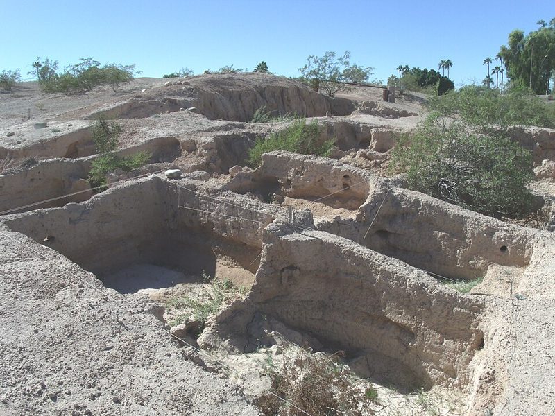
Mesa's history begins well before European settlement. The Hohokam people occupied this part of the Salt River Valley from around 300 CE into the early fifteenth century, building one of the most sophisticated pre-Columbian irrigation networks in North America — a canal system that later settlers would reuse and extend. The Arizona Museum of Natural History in downtown Mesa holds significant collections on Hohokam culture, and the museum also oversees a nearby Hohokam structure site dating to 1100–1400 CE.
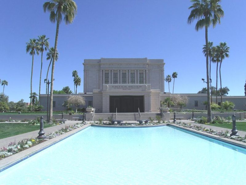
Modern Mesa was founded in March 1877, when Mormon pioneer Daniel Webster Jones led a group of Latter-day Saints settlers — arriving in 15 wagons — to establish an agricultural community in the Salt River area. The LDS community built irrigation canals (partly tracing Hohokam routes) within months, and the settlement grew into the city it is today. The Mesa Arizona Temple of The Church of Jesus Christ of Latter-day Saints, whose construction was announced in 1919, remains one of the most prominent landmarks in the city and a significant site for LDS visitors worldwide.
What to See and Do
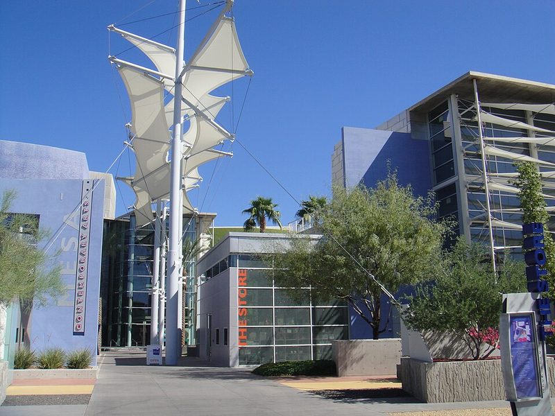
Downtown Mesa has a compact cultural district that rewards an afternoon on foot. The Arizona Museum of Natural History (53 N. Macdonald) covers dinosaur paleontology, Hohokam village reconstructions, and Southwest life and art. It is one of the more substantive regional natural history museums in Arizona. The Mesa Arts Center — the city's main performing arts and visual arts venue — presents theatre, music and gallery exhibitions throughout the year, and hosts an annual Día de los Muertos event in the autumn.
The Park of the Canals preserves visible traces of the Hohokam irrigation system within a public park setting, offering one of the more unusual heritage walks in the Phoenix metro. The Arizona Commemorative Air Force Museum (at Falcon Field) houses a collection of vintage military aircraft and is considered one of the more distinctive attractions in the East Valley.
The Mesa Music Festival is a free annual event held in downtown Mesa, billing itself as Arizona's premier emerging artist festival, with over 200 performances across rock, hip-hop, country, indie and folk genres. The city also holds an Arizona Celebration of Freedom event downtown each summer, with vendors, live music and fireworks.
The Desert Beyond the City
Mesa's greatest asset for active visitors may be its proximity to genuine wilderness. The Superstition Mountains lie to the east and are accessible as a day trip via the Apache Trail — a route that passes Canyon Lake and reaches into the Superstition Wilderness Area. The Dolly Steamboat operates cruises on Canyon Lake. Saguaro Lake, also reachable from Mesa, offers boat tours via the Desert Belle. The Salt River Wild Horses — a herd of feral horses living along the Lower Salt River within the Tonto National Forest boundary — have become one of the region's more talked-about natural sights and are accessible from the eastern edge of the metro area.
Summer heat (regularly exceeding 40°C) makes morning starts essential for any outdoor activity between June and September. October through April is the practical season for hiking and lake trips.
Practical Notes
Mesa operates on the America/Phoenix timezone, which does not observe daylight saving time — a detail worth noting when coordinating with contacts elsewhere in the US during summer months. The city has full urban services: reliable water, power and connectivity. Healthcare facilities serve a population of nearly half a million. Accommodation and dining options span the full range expected of a major American city, concentrated around downtown Mesa, the Red Mountain area and near the US 60 corridor, though visitors should confirm current options locally. For current event schedules, opening hours and accommodation availability, the Visit Mesa tourism office (visitmesa.com) is the most reliable local resource.
Superstition Mountains and the Apache Trail
The Superstition Mountains rise from the desert roughly 40 miles east of downtown Mesa, within the Tonto National Forest. The range's volcanic cliffs, Sonoran Desert trails and the reservoir-studded Apache Trail make this the most visited natural area within reach of Mesa-based visitors.
Lost Dutchman State Park (6109 Apache Trail, Apache Junction) serves as the main trailhead. Hikes range from short desert walks to the demanding Flatiron via Siphon Draw route — a five-to-six hour round trip to a summit with panoramic views. The park takes its name from a nineteenth-century legend about a lost gold mine, a story that remains part of the area's identity.
State Route 88, the Apache Trail, runs from Apache Junction through the mountains to Roosevelt Dam — dedicated by Theodore Roosevelt in 1911 as one of the first US federal reclamation projects. Canyon Lake, roughly 15 miles along the route, offers boating and the Dolly Steamboat nature cruise. Tortilla Flat, a former construction staging post from 1904, sits further along the trail.
The cooler months from October to April are the practical season for hiking. Summer temperatures regularly exceed 40°C, and hiking in midday heat carries real risk. Private vehicle is the only practical way to reach the area from Mesa. Current road conditions, entry fees and cruise schedules should be confirmed before visiting.
Read the full Superstition Mountains and the Apache Trail guide
Sources: Apache Trail and Superstition Mountain - Visit Mesa • Superstition Mountains - Visit Mesa • Superstition Mountains - Visit Phoenix • The Apache Trail - DesertUSA • Apache Trail scenic drive - Hike Bike Travel
Salt River Wild Horses
A free-roaming herd of wild horses lives along the lower Salt River, within the Tonto National Forest north of Mesa. The horses graze on river vegetation, wade through shallows and move along the banks — often in plain view of visitors who come specifically to watch them. Research suggests they are descendants of Spanish horses brought to Arizona in earlier centuries, though the exact lineage is debated. What is documented is that they have roamed this section of the national forest for generations and, since 2017, have been protected under Arizona state law.
Conservation and Management
The Salt River Wild Horse Management Group (SRWHMG) has managed the herd under contract since 2018, using a fertility control programme to keep the population at levels compatible with the habitat. The horses are described by conservation groups as an historic and iconic population — unbranded, unclaimed and born in the wild. Their legal protection under state law followed a public campaign in 2015, when the US Forest Service proposed removing the herd. The reversal of that decision, and the subsequent state legislation, made the Salt River horses one of the more closely watched wild horse populations in the United States.
Viewing the Horses
The horses roam the lower Salt River recreation area within the Tonto National Forest. They are most reliably seen in early to late spring, when they tend to gather near the river. Early morning and late afternoon are reported as the best times of day, when the animals are more active. Visitors may spot them grazing on riverbanks, wading through the water, or moving across the riverbed. Because this is a wild, free-roaming population, sightings cannot be guaranteed on any given visit.
The same stretch of the Salt River is popular for kayaking and tubing during warmer months, and horses are sometimes visible from the water. Visitors on river activities should check current conditions and operator availability locally, as these change seasonally.
Getting There
The lower Salt River recreation area sits north of Mesa, accessible by car via Bush Highway (State Route 87). Private vehicle is the standard approach; visitors should check current access points and any permit requirements with the Tonto National Forest before visiting, as conditions and access arrangements can change.
Sources: Guide to Salt River Wild Horses - Visit Mesa • Salt River Wild Horse Management Group • Salt River - Visit Phoenix • Where to see Salt River Wild Horses 2025 - Ray Redstone
Mesa Music Festival
The Mesa Music Festival is a free, all-ages event held annually in downtown Mesa. Organised along Main Street, it positions itself as a platform for emerging musicians alongside established performers, with over 200 performances across multiple stages. Visit Mesa describes it as the largest free emerging artist festival of its kind in the United States, a claim the festival's own organisers repeat. The 8th annual edition is scheduled for October 2026, with dates confirmed as 15–17 October.
Format and Programming
The festival takes place along Main Street in downtown Mesa over multiple days in October. Genres represented include rock, hip-hop, country, indie and folk — the programming spans a wide range rather than targeting a single audience. The festival accepts submissions from artists, and the organisers describe it as welcoming both industry veterans and newer performers. The free admission and all-ages format make it accessible to a broad cross-section of local and visiting audiences.
Downtown Mesa Context
The festival's location on Main Street places it in the area that Mesa has developed as its arts and cultural district. The Mesa Arts Center — the city's main performing arts venue — sits in this part of downtown, and the area includes a sidewalk sculpture gallery and permanent public art installations connected to the Valley Metro light rail route. The light rail's Centre and Main Street stop serves the Mesa Arts Center directly, providing a car-free option for visitors coming from Tempe or Phoenix for festival events.
Practical Notes
Admission is free and the event is all-ages. The 2026 dates are confirmed as 15–17 October; visitors should verify the programme and any stage-specific details via the official festival website or the City of Mesa events calendar before attending, as lineups and logistics are confirmed closer to the event. October falls within Mesa's cooler season, making outdoor events more comfortable than during summer months.
Sources: Mesa Music Festival - official site • Guide to the Mesa Music Festival 2026 - Visit Mesa • Mesa Music Festival - City of Mesa