


In This Guide
Read the guide as a story
The Monsoon Train: Arriving in Mumbai by Rail
Mumbai, Maharashtra
Few cities announce themselves quite like Mumbai. The moment you step out into its salt-thick air — somewhere between the shriek of a local train and the smell of chai from a pavement stall — you understand that this place runs on a frequency all its own. India's financial capital and most populous city proper, with a population of over 12.6 million, Mumbai is simultaneously the country's money engine, its dream factory, and one of the most layered urban environments on earth.
First Impressions and Setting
Mumbai sits on the Konkan coast on India's western seaboard, occupying a narrow peninsula that juts into the Arabian Sea. The city is low-lying — barely above sea level — and the sea is never far from view or mind. What you notice first is the density: towers pressing against colonial-era facades, fishing villages wedged between expressways, the Bandra-Worli Sea Link arcing across the water as an unmistakeable emblem of 21st-century ambition. That 5.6-kilometre cable-stayed bridge, the first of its kind built over open seas in India, carries road traffic between the western suburbs and the southern peninsula and has materially shortened journey times along one of the city's most congested corridors. To the east, the terrain rises gently toward Ghatkopar, where the topography begins to hint at the hills behind the city's flat coastal plain.
History, Identity and Local Stories
The city's origins lie with the Koli fishing communities, who have inhabited these shores for centuries and whose presence is still felt in the coastal neighbourhoods today. The Portuguese arrived in the sixteenth century, followed by the English, who received the islands as part of a royal dowry and eventually leased them to the East India Company. The colonial name Bombay survived into the late twentieth century — the city was officially renamed Mumbai in 1995 — and many residents still use both names interchangeably. Mumbai hosted the first session of the Indian National Congress in 1885, a moment with consequences that shaped the entire subcontinent. That layering of indigenous, colonial, and post-independence identity is visible everywhere: in the Gothic Revival and Art Deco architecture of the southern districts, in the Koli fishing boats still moored along the western seafront, in the Bollywood studios that have made this city the storytelling capital of South Asia.
Daily Life, Economy and Culture
Mumbai is home to more billionaires than any other Asian city, while simultaneously containing Dharavi, one of the largest and most economically active informal settlements in the world. This is not a contradiction so much as a condition. The city runs on extraordinary organisational ingenuity: the dabbawala network, in which thousands of lunchboxes are collected from homes across the city and delivered to offices with near-perfect accuracy using the suburban railway, has been studied by business schools worldwide as a logistics model. The Bandra Kurla Complex, a few kilometres from the older city centre, has become the address of choice for financial institutions and multinational offices — a planned district that reflects how rapidly Mumbai has expanded its economic geography beyond its colonial core.
What Visitors Notice
The suburban railway is the city's circulatory system, carrying millions of passengers every day and connecting neighbourhoods that would otherwise feel entirely separate. For visitors, the experience of the local train — packed during rush hours with a cross-section of the entire city — is itself one of the more honest introductions to how Mumbai actually moves. Juhu Beach, on the western seafront, draws both local families and visitors, functioning as the kind of democratically shared public space that large Indian cities tend to produce naturally.
The Bhau Daji Lad Mumbai City Museum, housed in a restored Victorian building in the Byculla area, is one of the city's most respected cultural institutions, holding collections that relate directly to the history of Mumbai and the region. The Gateway of India, the ceremonial arch on the harbour front in Colaba built to commemorate the 1911 royal visit, remains one of the city's most recognised landmarks and a practical hub for the harbour area. Bollywood studio tours, departing from the Film City complex in Goregaon, offer a different perspective on the industry that has made Mumbai the dominant centre of Indian popular cinema for a century.
Ganesh Chaturthi, the ten-day festival marking the birth of the elephant-headed deity Ganesh, transforms Mumbai every August or September. The Lalbaugcha Raja idol in Lalbaug, one of the most visited in the city, draws enormous crowds during the festival period. Visitors planning to be in Mumbai at this time should be aware that the city reaches a different order of intensity — extraordinary to witness, but demanding in terms of crowd management and transport.
Getting There and Around
The city's main international airport — Chhatrapati Shivaji Maharaj International Airport — sits in the Andheri area of the western suburbs and is one of the busiest in South Asia, handling flights from across the world. From the airport, taxis and app-based cabs connect to most parts of the city; the expanding metro network is adding airport-adjacent connections as infrastructure develops.
The suburban rail network is the practical backbone of movement within the city. Kurla Junction and Lokmanya Tilak Terminus are two of the major rail hubs in the city's central-eastern area, with Lokmanya Tilak Terminus handling significant long-distance traffic from other Indian cities in addition to suburban services. Vidyavihar station connects into the wider network a short distance away. Ghatkopar, slightly further east, functions as both a suburban rail stop and a key interchange on the metro system.
Mumbai's public transport operates across multiple modes. The BEST (Brihanmumbai Electric Supply and Transport) bus network covers the city extensively, with routes running from Colaba in the south to Mira Bhayandar in the north; the NMMT bus service extends further into Navi Mumbai and reaches destinations including Belapur and Panvel. The metro network has expanded in recent years, offering an alternative to overcrowded surface rail on certain corridors. Auto-rickshaws operate widely in the suburbs; black-and-yellow taxis are a fixture in the older southern parts of the city. Visitors navigating the local train or bus system are advised to download the m-Indicator app, which provides timetables, route maps and interchange information in one place. Current routes, fares and operating notices should always be confirmed with official operators before travel.
Walks and Viewpoints
Mumbai's terrain is predominantly flat, but the eastern suburbs offer modest elevation changes. Ghatkopar Hill, a few kilometres east of the Kurla–Ghatkopar corridor, provides a break from the relentless density of the lowland city. The western seafront, from Marine Drive in the south through Juhu and beyond, offers extended flat walking along the Arabian Sea. The southern peninsular areas — Colaba, Fort, Malabar Hill — reward walking between colonial and post-independence buildings, particularly in the cooler months between November and February when the humidity drops to manageable levels.
Nearby Areas and Day Trips
Mumbai's urban agglomeration spreads well beyond the city proper. Navi Mumbai, across the harbour to the east, was developed from the 1970s as a planned satellite city and is now home to more than 2.6 million people, with its own commercial centres and transport infrastructure. Dharavi, immediately adjacent to the Bandra Kurla Complex, is one of the most written-about urban communities in the world — economically active, densely organised, and frequently misrepresented in outsider accounts. Bandra, a few kilometres north of the sea link's southern anchor, is one of the city's most commercially lively neighbourhoods. NMMT bus routes connect Mumbai to Belapur, Panvel and points further into the Konkan hinterland for those wanting to reach areas beyond the metro region.
Family and Rainy-Day Activities
Mumbai has options for families and for days when outdoor plans are disrupted. The Bhau Daji Lad Museum, with its restored Victorian interior and collections covering the city's history, works as a half-day activity in any weather. The city's cinema culture — both mainstream multiplexes and occasional independent screenings — reflects its Bollywood heartland status. Juhu Beach functions as an accessible outdoor destination for families, particularly in the cooler season, though it draws crowds at weekends. Visitors with children should factor in travel time across the city: distances between attractions are substantial, and peak-hour rail and road congestion can be severe.
Practical Notes
Mumbai's monsoon runs roughly from June through September and is serious. The city receives heavy rainfall during this period, with flooding in low-lying areas a known and recurring feature of the season. Visitors planning to travel during monsoon should check conditions and allow for disruption. The period from November to February offers the most comfortable conditions for walking and sightseeing — cooler temperatures, lower humidity, and generally reliable weather. Peak visitor and festival pressure builds particularly around Ganesh Chaturthi (August–September) and during the winter season when the city is at its most comfortable for outsiders.
Official travel guidance from the UK FCDO advises against all travel to specific parts of India: areas within 10 km of the India-Pakistan border, the Union Territory of Jammu and Kashmir (with exceptions for Jammu city), and Manipur state. None of these restrictions apply to Mumbai. The US State Department carries no specific advisory level for India at the time of writing, but visitors should consult current official advice before departure. UK guidance is available at gov.uk/foreign-travel-advice/india and US advice at travel.state.gov.
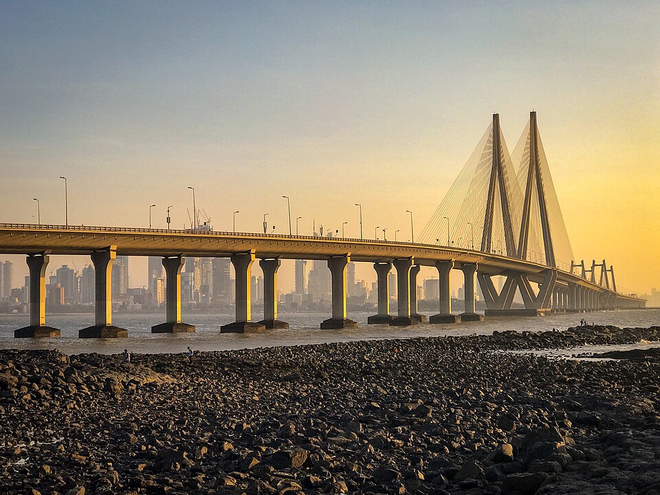
Mumbai Bandra-Worli Sea Link
The Bandra-Worli Sea Link is a 5.6-kilometre cable-stayed bridge crossing Mahim Bay, connecting the western suburb of Bandra to Worli on Mumbai's southern peninsula. Opened in 2009 and operated by the Maharashtra State Road Development Corporation, it was the first open-sea cable-stayed bridge built in India and has materially shortened road journey times between the western suburbs and south Mumbai. The bridge carries road traffic on an eight-lane carriageway and is tolled. Visitors in taxis will typically cross it automatically on journeys between Bandra and destinations such as Colaba or the Gateway of India. The bridge is also a recognised visual landmark, illuminated at night and visible from Worli seafront. It should not be confused with the separate Mumbai Trans Harbour Link, which connects Mumbai to Navi Mumbai across the eastern harbour.
Sources: Bandra Worli Sea Link - Iconic Mumbai Landmark - Incredible India • Mumbai Trans Harbour Link - Wikipedia • Bandra Worli Sea Link - MSRDC project page • Mumbai Local Transportation Guide - Mumbai Orbit
Stations, airports and arrival routes for Mumbai
Mumbai is served by Chhatrapati Shivaji Maharaj International Airport (Andheri), multiple long-distance rail termini including Lokmanya Tilak Terminus (Kurla) and CSMT (Fort), a dense suburban rail network on three principal lines, an expanding metro system, and the BEST bus network covering the city from Colaba to Mira Bhayandar. Kurla Junction is a key suburban interchange. The m-Indicator app is the most practical tool for navigating timetables across modes. NMMT buses extend coverage to Navi Mumbai and Panvel; MSRTC coaches serve destinations across Maharashtra. Current fares and timetables should be confirmed with official operators before travel.
Read the full Stations, airports and arrival routes for Mumbai guide
Sources: Transport in Mumbai - Wikipedia • Mumbai BEST Bus Route Maps - SUM Net India • MSRTC Bus Timetable Search - Routes and Timings Online