In This Guide
Read the guide as a story
Across Two Continents: An Istanbul Music Time-Slip
A Visitor's Guide to Istanbul
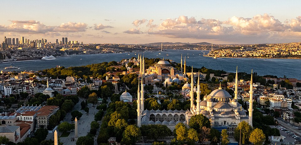
Istanbul is where Europe and Asia face each other across a narrow channel of water — the Bosphorus — and where Byzantine domes, Ottoman minarets and contemporary high-rises occupy the same skyline. With a population of around 15.7 million, it is Turkey's economic and cultural capital, a working port city that has been continuously settled and contested for more than two thousand years. Very few cities carry this much accumulated history while simultaneously operating at this pace and scale.
First Impressions and Setting
Istanbul sits at the meeting point of the Black Sea and the Sea of Marmara, divided by the Bosphorus strait. About two-thirds of the population lives on the European side; the rest live across the water on the Asian shore. The city is hilly, dense and rarely quiet. Ferries cross the strait constantly, traffic moves in unpredictable patterns, and the skyline shifts between low heritage districts and newer development. Average elevation is around 39 metres, but the topography means neighbourhoods stack and climb in ways that make walking more demanding than a flat map suggests. Districts like Haseki and Aksaray sit within the dense urban core, each with its own character within the wider metropolitan mesh.
What hits first-time visitors is scale. Istanbul is not a quiet city. Markets are loud, streets are busy, and the city hums with commerce, ferry horns, and movement.
History and Identity
Istanbul's identity is layered across centuries. It was Constantinople, capital of the Byzantine Empire, which means the city carries Christian heritage alongside its Ottoman and modern Turkish character. Byzantine structures survive throughout the city — the Basilica s. Petri in Ormisda, a former Byzantine church, is one marker of that deep past. When the Ottoman Empire made the city their capital, that transformation shaped its architecture, its neighbourhoods, its religious landscape and its relationship with trade routes that ran across three continents. The layering — Byzantine, Ottoman, Turkish Republican, contemporary — is visible in the built environment and forms the core of what makes Istanbul itself rather than merely any large metropolis.
The Beyoğlu district on the European side exemplifies this history in concentrated form. Its 19th-century architecture, the historic civic buildings along its main avenues, and the street life that spills down from Taksim Square reflect the city's cosmopolitan commercial past. The district is also one of Istanbul's main walking areas today, with a mix of residents, visitors and street-level activity that rewards slow exploration.
What to See
The historical peninsula holds centuries of architecture and streets that reward slow walking. The Hagia Irene, one of Istanbul's older Byzantine structures, sits within the grounds of Topkapı Palace and is listed among the city's museums. It is among the more distinctive heritage sites in the city, though visitors should confirm current access and opening arrangements locally before visiting, as status has varied.
The Galata Bridge connects the Eminönü and Karaköy neighbourhoods across the Golden Horn inlet. It carries both traffic and foot traffic, and the lower level has historically been known for fishing and waterside eating. The bridge is a practical crossing as much as a landmark, and walking it gives a ground-level sense of the water traffic that defines Istanbul's geography.
The Bosphorus itself is the city's defining geographical feature, and three bridges now span it. The Second Bosphorus Bridge (Fatih Sultan Mehmet Bridge) and the newer Yavuz Sultan Selim Bridge to the north are both engineering landmarks in their own right. Boat trips on the strait are a reliable way to see the city from the water — a perspective that makes sense given how much of daily life here depends on the channel between the two continents.
The Museum of Innocence in the Çukurcuma neighbourhood is an unusual cultural draw. Created by novelist Orhan Pamuk, the museum is built around the world of his 2008 novel of the same name and functions as a physical extension of the book's narrative. It has its own official website and opening hours, which should be checked directly with the museum before visiting.
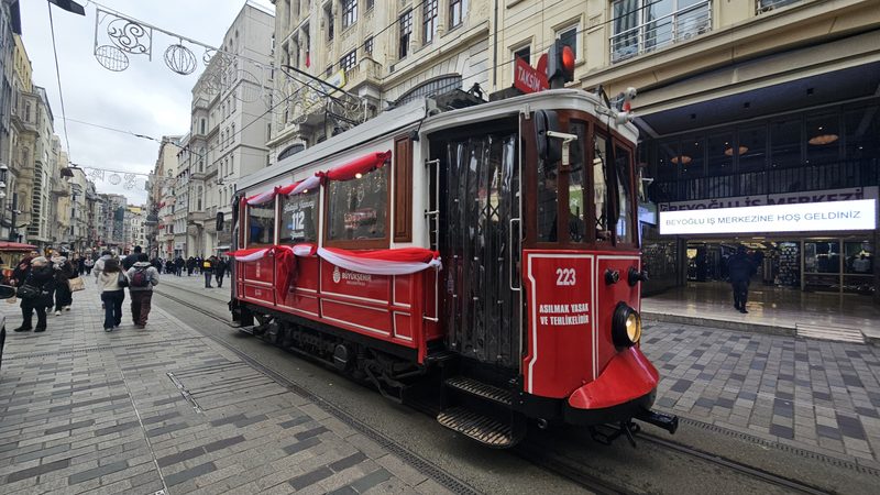
The Beyoğlu district, anchored by İstiklal Avenue and Taksim Square, is one of the city's main walking areas. İstiklal Avenue is a long pedestrianised street with significant 19th-century architecture, shops, cafés and a historic tram. The area connects to Galata and the Karaköy waterfront below, making it a natural route for several hours of exploration.
Food and Drink
Istanbul's food culture is consistent across visitor sources: eating well here is not difficult. Street food, traditional restaurants (lokanta), fish restaurants along the Bosphorus and the Karaköy waterfront, and coffee houses all form part of ordinary daily life. Turkish coffee has UNESCO recognition as a cultural practice, and the city's coffeehouse tradition goes back to the Ottoman period. Tea (çay) is the everyday drink and is available almost everywhere. Visitor feedback consistently rates food and drink among the city's strongest qualities.
Families and Rainy-Day Options
Istanbul has a range of options for families and for days when weather limits outdoor plans. Museums and covered markets provide indoor alternatives, and the city's ferry system gives children a genuine on-the-water experience rather than just a tourist boat ride. Sources confirm the city is workable for families, though the density and traffic of central districts can be tiring. Arriving early at heritage sites reduces crowding, particularly in peak season.
Seasonal Considerations
Peak seasons bring significant crowds to heritage areas. Visitor sources consistently flag crowding in high summer as the main friction point. Off-season visits — late autumn and winter — tend to feel quieter and less pressured, though some outdoor activities and Bosphorus boat tours are weather-dependent. The city does get rain; having indoor options ready is sensible at any time of year. Anyone wanting to avoid the most visitor-heavy periods should consider shoulder months (April–May and September–October), though these are popular too.
Who Will Enjoy Istanbul
Istanbul suits visitors who want genuine urban immersion alongside historical depth. The city works well for those interested in culture and history, food and drink, walking, and waterfront activity. It is a reasonable choice for families who can handle density and pace. Budget-sensitive visitors should check prices before committing — certain districts and visitor-facing establishments have moved upmarket, and some visitors note it can feel expensive or heavily commercialised in the most tourist-concentrated areas. Visitors who strongly dislike crowds should plan around peak summer and confirm timing locally.
Getting There
Istanbul is served by two main airports: Istanbul Airport (IST) on the European side, which handles the majority of international traffic, and Sabiha Gökçen Airport (SAW) on the Asian side. Both are connected to the city by public transport options including metro, bus and airport transfer services. Intercity coaches connect Istanbul to other Turkish cities and some European destinations; international rail services also operate. Visitors should confirm current airport and transport connections through carriers and transport operators before travel.
Getting Around
Istanbul has an extensive public transport network covering metro, tram, bus and ferry. The İstanbulkart contactless card is the standard payment method across all modes and is the practical choice for any visitor using public transport regularly — it works on metro, tram, bus and ferry services operated by the city's main transit providers.
Key lines for visitors include the T1 tram (Bağcılar to Kabataş), which passes through Zeytinburnu, Sultanahmet and Eminönü, covering the main heritage peninsula and the Galata Bridge area. The M2 metro runs from Yenikapı north through Aksaray and Taksim to Hacıosman, providing a fast north–south spine on the European side. Ferries cross the Bosphorus between the European and Asian shores — Kadıköy on the Asian side is reachable by ferry and has a tram line (T3) running to Moda. Bus lines 22, 25E and 40 serve Ortaköy. The İETT network covers nearly 500 bus lines across the city, though bus navigation is complex for first-time visitors.
For timetables, route maps and current fare information, the official sources are Metro Istanbul and İETT. Third-party guides such as Istanbul Tourist Information and Too Istanbul offer practical tourist-oriented explanations. Do not rely on WorldTownGuide for live timetables or fares — check official operator pages before travel.
Taxis are available across the city. Ride-sharing apps also operate. Many heritage-district journeys are walkable within neighbourhoods, though the overall scale of Istanbul means planning routes in advance is sensible.
Travel Advisory Context
Both the UK Foreign, Commonwealth & Development Office (FCDO) and the US State Department maintain travel advisories for Turkey. The UK advises against all travel within 10 kilometres of the Syria border, where armed conflict and terrorism risks are elevated; further southeastern provinces carry a "reconsider travel" designation. The US maintains a Level 2: Exercise Increased Caution advisory for Turkey overall, citing terrorism risks, armed conflict in border regions, and the possibility of arbitrary detention. Istanbul is not in the restricted zones covered by these specific warnings, but travellers should review current official guidance before departure and register with their embassy.
Consult the FCDO travel advice for Turkey or the US State Department travel advisory for the latest information.
Practical Notes
Istanbul operates on the Europe/Istanbul timezone. The city is large enough that what takes five minutes in one neighbourhood might take an hour from another, depending on traffic and distance. Turkish is the working language; outside major tourist areas, English is less reliably available, so carrying a translation tool or learning a few basic phrases helps. Tourist-oriented information is widely available in heritage districts. Local sources — residents, neighbourhood cafés, local transport apps — often give more accurate real-time guidance than any printed guide.
Getting around Istanbul without a car
Istanbul's public transport network — tram, metro, bus and ferry — is extensive and runs on the İstanbulkart contactless card. The T1 tram covers the historical peninsula from Bağcılar to Kabataş via Sultanahmet and Eminönü. The M2 metro connects Yenikapı, Aksaray, Taksim and Hacıosman on the European side. Ferries link the European and Asian shores, and the bus network (İETT) covers nearly 500 lines. For current timetables and fares, use the official Metro Istanbul and İETT websites.
Read the full Getting around Istanbul without a car guide
Sources: Public Transport in Istanbul: Metro, Tram, Ferry, Prices and Tips for Tourists - Istanbul • Our guide to public transportation in Istanbul - Too Istanbul • Istanbul Public Transportation: A Survival Guide for Travelers - Nomadic Niko • Metro Istanbul - Fares and Ticket Prices • IETT - Istanbul Bus and Tram Operator • Istanbul Airports, Bus, Tram, Train, Taxi, Metro, Ferry and Ship - Turkey Travel Planner
Galata Bridge
Galata Bridge, Istanbul
The Galata Bridge crosses the Golden Horn inlet, connecting the Eminönü neighbourhood on the historical peninsula with Karaköy and the Galata district to the north. It carries both road traffic and pedestrians, and the lower deck has a row of waterside establishments. Walking the bridge gives a direct sense of the water traffic — ferries, working boats and pleasure craft — that has defined this crossing point for centuries.
The bridge is part of the T1 tram route, with stops at Eminönü on the southern end and Karaköy on the northern end. It is also a practical link for walkers moving between the historical peninsula and Beyoğlu. Fishing from the bridge is a visible and persistent local habit, and the railing lined with fishing rods is one of the more distinctive everyday sights in central Istanbul.
Source depth on the bridge's current operational detail is limited in the research packet. Visitors should treat this as orientation information rather than a comprehensive guide to the bridge's facilities or lower-deck establishments, which should be checked locally.
Sources: Bridges of Istanbul: Where Europe and Asia Meet 2026 - Istanbul Tourist Information