What Kendal is known for
Kendal sits at a crossroads between the English Lake District and the wider countryside of Cumbria, a grey-stone market town built along the River Kent valley. For nearly a thousand years it has served as a working hub for the surrounding region—a place where farmers, travellers, and traders have passed through, where industries rose and fell, and where the character of northern England shaped itself around water, stone, and human ambition.
First Impressions and Setting
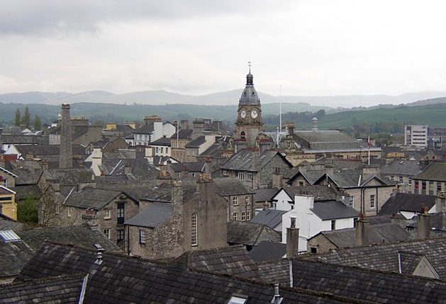
The town spreads across relatively modest terrain at 55 metres elevation, cradled by the valley that gives Kendal its name. The River Kent flows through it, and the landscape around holds that particular quality of the North—not mountainous exactly, but undulating and green, with the Lake District proper beginning just a few miles away. Visitors arriving from the south via the M6 motorway (junction 36 lies nearby) notice the grey stone buildings that line the town, quarried and built locally over centuries. This vernacular architecture—what locals have historically called "the auld grey town"—gives Kendal a cohesive, weathered character distinct from the softer stone settlements elsewhere in the region.
History, Identity and Local Stories
Kendal's past is rooted in its strategic position. The Romans built a fort here, Alauna, on the River Kent's bank during the 1st century. By the time of the Domesday Book in 1086, the settlement was already established as Kirkby or Cherchebi, drawing its medieval name from Old Norse—"village with a church." In 1189, King Richard I granted a market charter to Baron Gilbert Fitz-Renfried, an act that secured Kendal's future as a market town and, notably, helped fund Richard's crusade to the Holy Land. That market charter shaped centuries of local commerce and social life.
Kendal Castle was built in the late 12th and early 13th centuries, standing on a glacial drumlin to the east of the town centre. By the 15th century, the Parr family—a landowning dynasty of regional importance—controlled the castle and held sway over the barony. The castle's most famous connection is to Katherine Parr, the sixth and last wife of Henry VIII, whose family owned the castle though local legends about her birthplace remain unconfirmed. The castle itself dates to around 1241, built with six towers linked by curtain walls above a deep dry moat. The Barony of Kendal was originally granted to William de Lancaster around 1150, and over subsequent centuries passed through the hands of families whose names mark medieval northern history—the Brus, Lindsay, Ros, and Thweng lines.
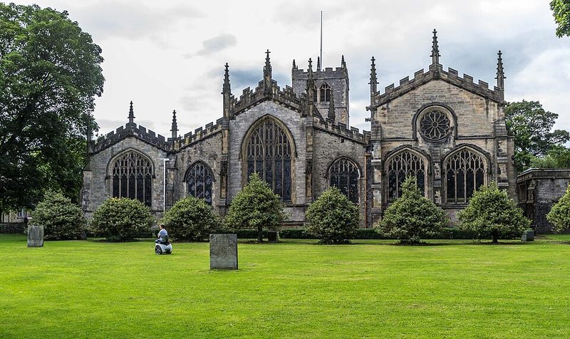
Medieval Kendal, like many northern towns, knew violence. In 1210, Scottish raiders under the Earl of Fife devastated the settlement, ransacking buildings and killing refugees who had fled to the parish church. That resilience—the ability to rebuild and continue—became part of the town's character. The Church of Holy Trinity, built around 1201, replaced an earlier Saxon structure and still stands in the town centre.
Daily Life, Economy and Culture
For most of its working history, Kendal's economy turned on textile manufacture. Wool formed the foundation: the town's coat of arms carries a Latin motto referencing cloth, a reminder that this trade defined it. The arrival of the Lancaster Canal in 1819 transformed productive capacity, though the canal itself closed in 1944. More significant was the railway: the Lancaster and Carlisle line opened in 1846, with a branch to Windermere following in 1847. Steam power reached the woollen mills from 1843 onwards, scaling production dramatically.
The evidence records specific mills by name and function: Dockray Hall Mill (built 1788, later producing carpets from around 1830); Castle Mills (1806, expanded in 1855 for power loom weaving); Low Mills (rebuilt 1806 as a woollen fustian mill, later home to iron founding around 1840). Carpet-making became a speciality from 1822. Hosiery and sock manufacture followed, with operations like E W Thompson and Sons running from the 1870s into the late 20th century. Iron founding developed after the canal and railway, using imported coal and iron transported by those same routes.
This industrial history is not merely archival: it explains the town's layout, its bridges, its relationship to the river, and the families who built fortunes and shaped local institutions. Many of those mills have closed or been repurposed, but their presence remains visible in the urban landscape.
Museums and Cultural Institutions
The town holds two museums, though current visiting arrangements should be confirmed locally. The Quaker Tapestry Museum, housed in the Friends' Meeting House—a Grade II listed building designed in 1816 by architect Francis Webster and regarded as one of the finest examples of Georgian architecture in Cumbria—displays an award-winning exhibition of embroidered panels created by 4,000 volunteers from around the world over 15 years. The 77 panels tell stories spanning 350 years of Quaker social history, covering topics from railways to revolutionary ideas. The building itself has served as a centre for Quaker worship for over 300 years. The museum was offering regular crafting sessions and embroidery kits, though visitors should verify current opening status before planning a visit.
What Visitors Notice
Kendal functions today as a gateway to the Lake District. Windermere lake lies about nine miles away, and the broader fell country is within easy reach. The town itself holds Kendal Castle (now ruins) and the museums mentioned above. The River Kent runs through, crossed by multiple historical bridges. Low crime and good local schools signal a settled, functioning community rather than a tourist town dependent on seasonal visitors.
The character of the place emerges from walking it: the stone buildings, the market tradition still active in local life, the sense of a town that serves residents first and welcomes visitors second. The landscape around is green and accessible, neither remote nor suburban—a working corner of northern England where fell-walking, market shopping, and daily life coexist naturally.
Getting There and Around
Kendal is reached by car via the M6 motorway, with junction 36 providing direct access. The town benefits from a railway station on the line to Windermere (opened 1847) and the broader rail network. Bus services connect the town to surrounding areas, though specific routes and operators should be verified locally. For those visiting the Lake District, Kendal serves as a practical base—closer to road and rail than some fell-side villages, yet embedded in the landscape rather than isolated from it.
Practical Notes
The town has accommodation ranging from hotels and bed-and-breakfasts to holiday cottages, glamping and camping sites, and hostels. Restaurants and public houses operate throughout the town. Winter brings reduced daylight at this northern latitude (54.3 degrees north), so seasonal visitors should plan accordingly. Local knowledge is thin in the available sources on many practical details; visitors with specific questions will find local visitor information and community websites most helpful.