In This Guide
Read the guide as a story
The Casket Girls and Other Stories: New Orleans at Night
New Orleans at a Glance
New Orleans is Louisiana's most populous city, occupying a crescent of land along the Mississippi River in the state's southeastern corner. It is a genuine regional hub for commerce, healthcare and culture, and draws visitors primarily for its concentration of music, historic architecture, food traditions and annual festivals. The French Quarter, the Mississippi riverfront, the city's streetcar network and a calendar that runs from Mardi Gras through Jazz Fest give the city a density of things to do that few American cities match. Visitors who enjoy walking, live music, food and drink, and layered history are well served; those who dislike crowds should plan carefully around peak periods, particularly the weeks around Mardi Gras.
Setting and First Impressions
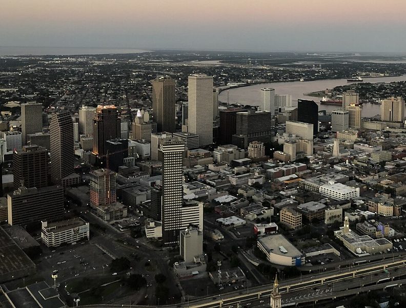
The city sits coextensive with Orleans Parish, bounded by the Mississippi to the south and Lake Pontchartrain to the north. The river is not merely backdrop: it carries heavy commercial freight and supports one of the most significant port operations on the Gulf Coast. The broader metropolitan area approaches one million residents, and the contrast between the Central Business District's skyline and the low-slung painted timber houses of older neighbourhoods is something visitors notice almost immediately.
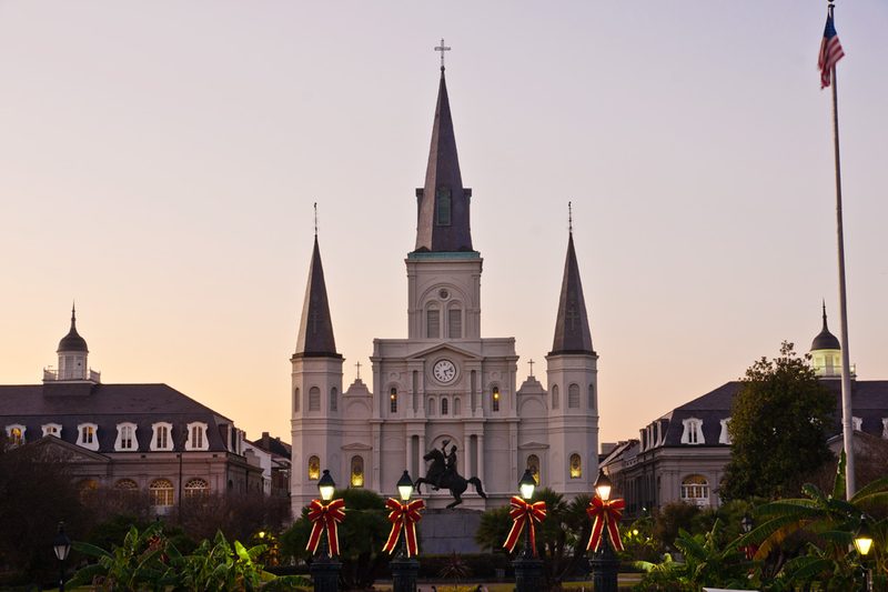
The French Quarter — the Vieux Carré — is the oldest part of the city and the area where most first-time visitors orient themselves. It follows the original colonial street grid, with cast-iron galleries, interior courtyards and narrow streets that reflect successive layers of French, Spanish and American occupation. Jackson Square, fronted by the Cathedral Basilica of Saint Louis, King of France, functions as the civic and visual centre of the Quarter and is one of the most recognisable public spaces in the American South. The square also serves as an open-air market space for vendors and street performers.
Beyond the Quarter, the Garden District, the Arts and Warehouse District and Frenchmen Street (in the Faubourg Marigny neighbourhood) each offer distinct characters. Frenchmen Street in particular is noted as a centre of live music that operates with less tourist-facing packaging than Bourbon Street.
History and Identity
New Orleans was founded by French colonial planners and passed through Spanish governance before American acquisition. That layered colonial history, combined with the forced labour of enslaved Africans and strong Caribbean influence, produced a culture that diverges noticeably from the broader American South. The city's Catholic heritage — carried by both French and Spanish colonisation — shaped its religious architecture and its calendar of festivals tied to the liturgical year.
A 1724 architectural plan by Adrien de Pauger survives as an early document of the city's ambitions, drawn for what would become the Saint Louis Parish Church. The church built to that design was dedicated on Christmas Eve 1727, only to be destroyed by fire in 1788. That cycle of construction, disaster and rebuilding has repeated itself throughout New Orleans history and remains part of its character.
The Immaculate Conception Catholic Church on Baronne Street — also known as the Jesuit Church — is one of the city's significant religious landmarks and represents the depth of that Catholic tradition. The Fourth Presbyterian Church adds another thread to the city's complex record of faith communities across different eras.
Storyville, a district just north of the French Quarter, was established in the late nineteenth century as a legally defined zone for prostitution. It became simultaneously notorious and historically significant through its association with the early development of jazz. Federal authorities abolished it in 1917, and the physical neighbourhood was largely demolished in later decades, but its name persists as a reference point in discussions of jazz origins and the city's more complicated social history.
New Orleans also carries a strong tradition of local legend and folklore. The Ursuline Convent — among the oldest surviving buildings in the Mississippi Valley — features in several of the city's best-known ghost stories, including the tale of the "casket girls": a group of young women who arrived from France in 1728 to marry colonists, and whose trunks, it was later said, were not carrying clothes. The Historic New Orleans Collection documents stories of this kind alongside more grounded local history, and the city archives hold the primary record for many of these accounts.
What Visitors Notice
Walking through the French Quarter, the Cathedral Basilica of Saint Louis at Jackson Square is an obvious early landmark. The New Orleans Historic Voodoo Museum is among the named sites that appear repeatedly in visitor accounts of the Quarter; it sits within the broader context of the city's well-documented interest in Voodoo traditions and supernatural folklore. The Old Absinthe House on Bourbon Street is another frequently mentioned stop. Visitors should check current opening status and hours directly with each venue before visiting, as this guide does not carry live operating information.
The New Orleans Jazz Museum documents the music's development and the city's central role in shaping American sound. Jazz here is not simply a tourist attraction: it is a living tradition with institutional support and a visible presence in venues across the city, from Preservation Hall in the French Quarter to the clubs along Frenchmen Street.
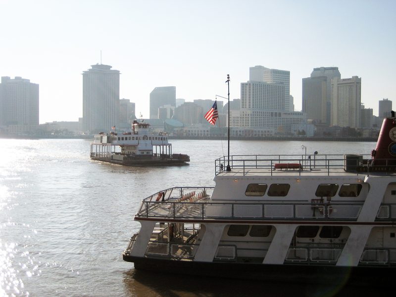
The Mississippi riverfront is accessible and worth time. The Algiers Ferry, which crosses between Canal Street and the Algiers neighbourhood on the West Bank, has long provided both a practical river crossing and a way to see the city from the water. The ferry is operated as part of the Regional Transit Authority network and accepts the RTA's Jazzy Pass; visitors should check current schedules and operating notices with NORTA directly.
City Park, located north of the French Quarter, offers a range of activities including paddleboats, a miniature train, a sculpture garden and the Louisiana Children's Museum — making it a practical option for families or for days when the city's frequent afternoon rainstorms make outdoor touring less appealing. The city's indoor cultural venues and museums provide further shelter and engagement on wet days.
Festivals and Seasonal Events
New Orleans runs one of the most event-dense calendars of any American city. Mardi Gras — the culmination of Carnival season — is the most internationally known, rooted in hundreds of years of tradition and tied to the Catholic liturgical calendar: Carnival begins twelve days after Christmas and runs until Fat Tuesday, the day before Ash Wednesday. The exact date shifts annually. The New Orleans Jazz and Heritage Festival (Jazz Fest) draws large crowds each spring. The ESSENCE Festival of Culture is another major annual event. Visitors planning travel around these events should book accommodation well in advance and expect significantly higher prices and crowd levels than at other times of year.
Outside festival periods, the city's shoulder seasons — broadly autumn and late winter — tend to offer more manageable crowds and lower costs, though the subtropical climate means heat and humidity are factors from spring through early autumn. Hurricane season runs from June through November, and visitors should monitor conditions during that window.
Getting There and Getting Around
Louis Armstrong New Orleans International Airport is the primary point of entry for air travellers. Amtrak serves the city through its station near the Central Business District, connecting New Orleans to national rail routes. Long-distance coach services including Greyhound and FlixBus also operate to and from the city.
Locally, the Regional Transit Authority (NORTA) operates the city's streetcar network — one of the oldest continuously operating systems in the United States — along with around 30 bus lines. There is no metro or subway: buses and streetcars are the backbone of public transport. The RTA's Jazzy Pass covers buses, streetcars and ferries. For route planning, the RTA provides a Trip Planner tool; real-time schedules are also available through apps including Moovit and Transit. Visitors should check current schedules and any service changes directly with NORTA at norta.com before travel.
Visitors staying in the French Quarter, Downtown or the Arts and Warehouse District may find they can manage most of a stay on foot, with streetcars or the ferry for longer trips. For areas beyond the core, rideshare services and taxis are widely available.
The Lake Pontchartrain Causeway links New Orleans northward across the lake toward the suburbs and the North Shore communities — one of the longest bridges over water in the United States. The Algiers Ferry crosses the Mississippi between Canal Street and the West Bank; it operates as part of the RTA network. Visitors taking day trips beyond the city will generally need a car or an organised tour for destinations such as the River Road plantation sites or the wetland areas to the south and west.
Day Trips from New Orleans
The wider region offers several practical day-trip options for visitors with more than two or three days in the city. The River Road plantation sites — including the Whitney Plantation, which opened to the public in 2014 as the only Louisiana plantation museum focused entirely on the history of enslaved people — lie west of the city and are most easily reached by car. Wetland tours into the bayou country south and west of the city are widely available as guided experiences. The North Shore communities across Lake Pontchartrain are reachable via the Causeway. Most day trips beyond the immediate metro area require a car or a booked tour; public transport options for out-of-city destinations are limited.
Practical Notes
The UK Foreign, Commonwealth and Development Office currently advises normal precautions for travel to the United States, with no elevated warnings in place. Visitors from countries in the US Visa Waiver Programme should ensure their ESTA is approved before departure. The city operates on Central Time. New Orleans has a subtropical climate: summers are hot and humid, and hurricane season (June to November) brings the risk of severe weather. Checking conditions before and during travel in that window is advisable.
Major medical facilities are available within the city, including Tulane University Hospital and Clinic and Tulane Hospital for Children. The FCDO travel advice page is at gov.uk/foreign-travel-advice/usa; the US State Department's guidance is at travel.state.gov.
Parking enforcement in the city is active: visitors arriving by car should read parking signs carefully before leaving a vehicle.
Wikipedia The Lake Pontchartrain Causeway
The Lake Pontchartrain Causeway spans roughly 38 kilometres of open water between the southern suburbs of New Orleans and the North Shore communities of Mandeville and Covington. It is a toll road and the primary road link for day trips to the North Shore. The crossing takes around 30 minutes and gives drivers an extended view across the open lake. Public transport does not use the Causeway. The lake itself defines New Orleans' northern boundary and has long influenced the city's geography and storm-surge exposure.
Read the full Wikipedia The Lake Pontchartrain Causeway guide
Sources: New Orleans Then and Now - the Skyline - Inside Adams, Library of Congress • Lake Pontchartrain Causeway - Wikipedia • Lake Pontchartrain - Wikipedia
Mississippi River
The Mississippi River curves around the southern edge of New Orleans, giving the city its "Crescent City" name. The riverfront is walkable from the French Quarter, and the Algiers Ferry — part of the RTA network, accepting the Jazzy Pass — crosses to the West Bank in minutes, offering views of the skyline. Passenger cruise boats and steamboat excursions also operate from near Jackson Square. The river carries heavy commercial freight, and its geography, combined with Lake Pontchartrain to the north, defines the city's flood exposure — a defining fact in New Orleans history since Hurricane Katrina.
Read the full Mississippi River guide
Sources: Huey P. Long Bridge (Jefferson Parish) - Wikipedia • Best Day Trips from New Orleans Under Three Hours - Travel on the Reg • Navigating New Orleans - neworleans.com
Getting around New Orleans without a car
Getting Around New Orleans Without a Car
New Orleans is one of the more manageable American cities for car-free visitors, at least within the core tourist areas. The French Quarter, Downtown and the Arts and Warehouse District are compact enough that many visitors find they can walk to most of their destinations. For longer journeys within the city, the Regional Transit Authority (NORTA) operates both streetcars and buses.
Streetcars
The streetcar network is both a practical transport option and a historic attraction in its own right. The St. Charles line runs through the Garden District and Uptown — one of the oldest continuously operating streetcar routes in the United States. The Canal Street and Rampart/St. Claude lines extend coverage further. Streetcars connect visitors to popular destinations including the French Quarter, St. Charles Avenue and the city's above-ground cemeteries. The historic character of the vehicles is a genuine draw, though services operate at standard urban transit frequency rather than on a tourist-circuit schedule.
Buses
NORTA operates around 30 bus lines across the city. New Orleans has no metro or subway system, so buses are the main public-transport option for destinations not covered by the streetcar lines. The RTA Trip Planner tool on the NORTA website helps with route planning. Real-time schedule information is also available through apps including Moovit and Transit.
The Jazzy Pass
NORTA's Jazzy Pass covers all RTA buses, streetcars and the Algiers Ferry. Visitors making more than a few journeys per day will find a multi-day Jazzy Pass more economical than single fares; current pass options and prices should be checked at norta.com, as these can change.
The Algiers Ferry
The ferry between Canal Street and Algiers Point is part of the RTA network and accepts the Jazzy Pass. It provides a free or low-cost river crossing (subject to current fare structure — check NORTA) and a practical way to reach the West Bank without a car.
Taxis and Rideshare
Taxis and rideshare services operate citywide and are a practical supplement for late-night travel or journeys to areas with limited transit coverage. Visitors should note that parking enforcement in New Orleans is active; those arriving by car should read signs carefully.
Reaching the Airport
Louis Armstrong New Orleans International Airport is served by bus links and taxi/rideshare services into the city. Visitors should verify current options and journey times with the airport and RTA before travelling, as service arrangements can change.
Sources: Navigating New Orleans - neworleans.com • RTA Bus Lines - neworleans.com • New Orleans RTA system map - norta.com • Transportation - Experience New Orleans